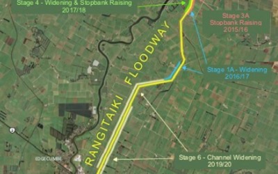
The Rangitāiki Floodway is a multi-stage project designed to take pressure off the Rangitāiki River in a flood event, by diverting some of its flow, via a spillway, into near-by farmland between stopbanks (known as the floodway) and out the Rangitāiki River mouth at Thornton.
Why are we doing this?
The Rangitāiki River has a long history of flooding. The results of a significant flood event can be catastrophic to the lives and livelihoods of those in flood-affected areas.
Between the 1960s and 1980s, the Rangitāiki Floodway was created by the Bay of Plenty Catchments Commission to provide flood protection to the community in and around Edgecumbe.
Over time, the level of flood protection that the floodway offers has decreased, due to the impacts of a changing climate – plus, as technology has advanced, we can better predict what flood events may look like and how our flood defences need to be constructed to meet future demands.
Flood protection is the first line of defence when it comes to reducing the impact of significant flooding, which is why we now have nearly $400M of flood protection defences across the rohe, such as floodwalls and stopbanks.
This project involves increasing the floodway’s capacity and upgrading the existing spillway to provide more assurance during a flood event.
In 2009, Regional Council was granted resource consent to increase the amount of water that could be diverted into the floodway (190 cubic metres per second) and upgrade the existing spillway to better control how the water gets into the floodway.
By diverting this water, in a controlled manner through the floodway during a flood event, we can reduce the flood levels in the Rangitāiki River downstream of the site, therefore reducing pressure on the river near populated areas (such as Edgecumbe).
Once completed, the floodway and spillway will form part of a network of protection along the Rangitāiki River. This includes the Rangitāiki Floodwalls and Lower Rangitāiki Stopbanks at the river mouth near Thornton. In a flood event, these flood defences will work together to help reduce the impact of flooding on near-by communities.
Crown Infrastructure Funding
Regional Council received funding for Stage 6 of the floodway and the spillway from Central Government’s Crown Infrastructure Funding for this project as part of the Climate Resilience Programme ($10.275M). This funding was granted as part of the Covid-19 Response and Recovery Fund, and was one of six projects Regional Council received funding for.
Construction to upgrade the floodway began in 2011 and was completed in 2023. There were seven stages of the project, each stage with its own engineering considerations.
Upgrades on the floodway included:
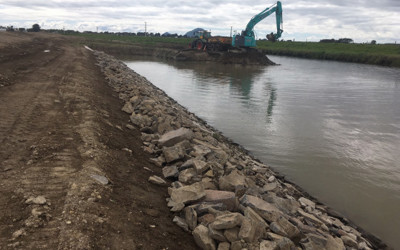
Sections of the existing floodway channel have been widened.
Stopbanks have been reconstructed to raise the bank heights.
Culverts have been upgraded to support the new stopbank design.
Greater seepage control beneath the ground has been installed.
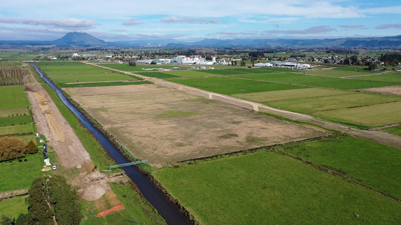
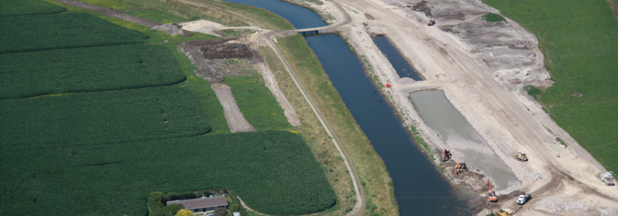
A new bifurcation cut was made at Thornton Hall Road. This allows water from the floodway to exit into the Rangitāiki River mouth at two places, instead of one.
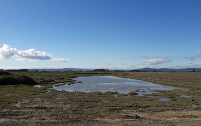
A road bridge was created over the new floodway exit and a wetland was established between the two exits as an ideal spot for inanga spawning.
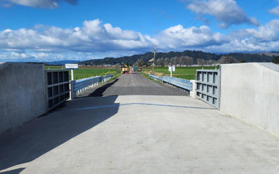
Installation of swing gates at McCracken and McLeans Road.
Rangitāiki Spillway – Construction began January 2024
Construction began on the Rangitāiki Spillway, located next to Hydro Road, in January 2024. This is the final stage of the floodway project.
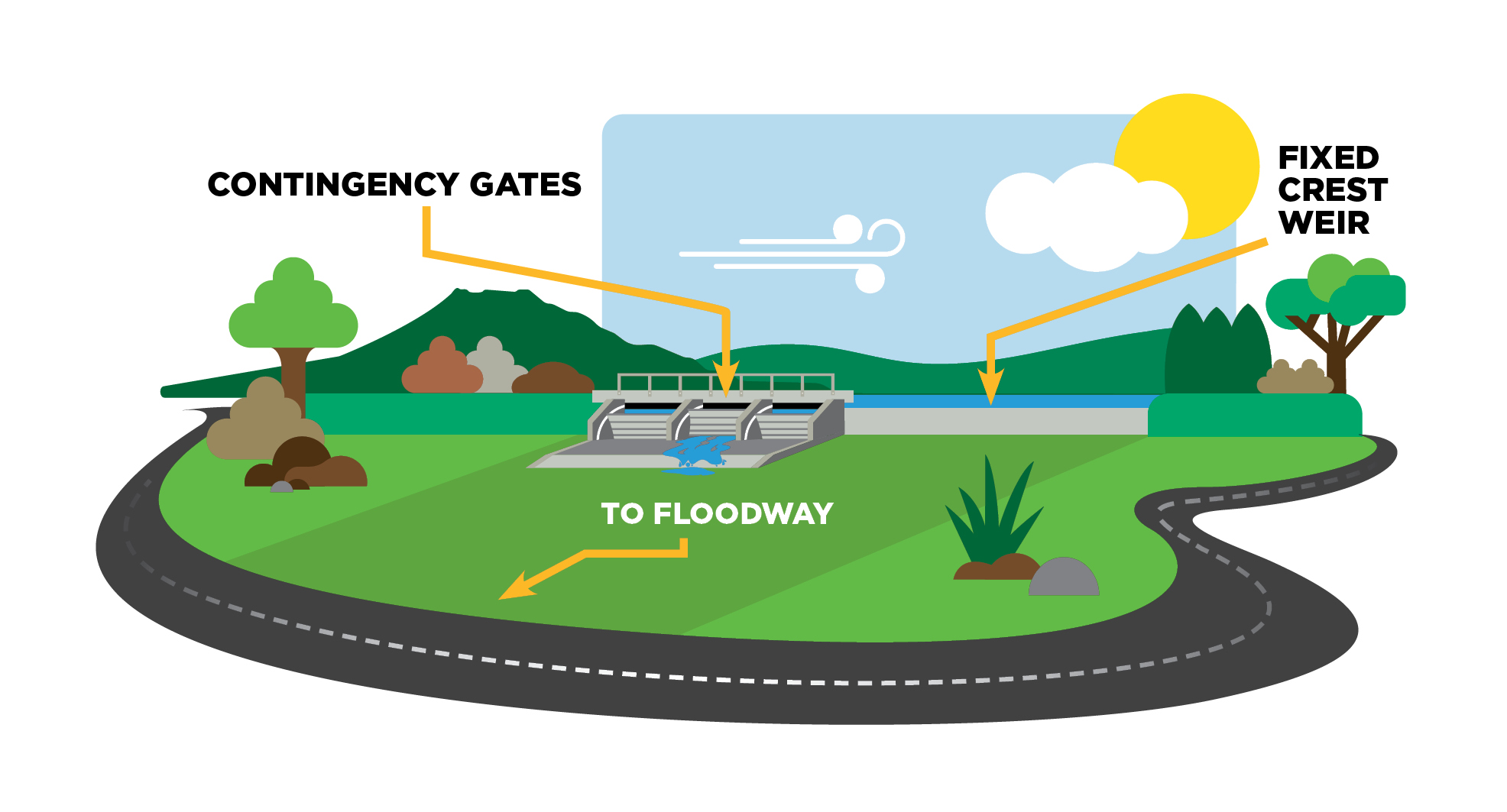
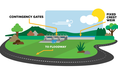
This involves constructing a 114m concrete capped fixed crest weir (a lower section of stopbank) to allow water to flow out of the Rangitāiki River in a controlled manner into the floodway. This has been designed based on what the predicted river level could be during operation and determines how much flow will go over the spillway.
When the river reaches a certain level, the spillway allows water to pass over the fixed crest weir and into an area of paddock near Hydro Road. This water is then channelled into the floodway and out to the Rangitāiki River mouth.
Radial (or contingency) gates will also be installed as an added layer of protection. When open, they direct river flow into the floodway before the river overtops the lowered section of stopbank.
Regional Council staff are working closely with affected landowners while construction is underway. If you have any questions or concerns, please direct them to engineering@boprc.govt.nz
Once complete, the spillway will ‘activate’ at a lower river level (a more frequent flood event).
However, the volume of water sitting in the floodway during a smaller event will be less – for example, there may be localised ponding or increased water levels in Reid Central Canal only (amount of water subject to size of flood event).
After initial community consultation in 2020, the detailed design phase began.
During this phase, river modelling and ground investigations identified key risks that needed to be addressed. These risks were seepage and erodibility (scour) of these structures when the spillway is in operation, as well as creating certainty that the spillway achieves required flows.
Based on this, the detailed design was developed to address the above issues.
Because of these design changes (and a few other factors), the estimated cost to upgrade the Rangitāiki Spillway increased to $7.8M (the initial estimate was $2.8M).
In April 2023, the community supported the updated design, and it was approved at a Regional Council meeting in May 2023.
The cost increase will be passed on to Rangitāiki-Tarawera Rivers Scheme ratepayers via targeted ratepayers over the next 20 years. There will also be a small increase in general rates.
In October 2022, we publicly notified the variation to the resource consent application, for the construction and operation of the spillway (located at 266 Hydro Road, Edgecumbe).
While consent was first granted in 2009, we reapplied for consent as the design and operation of the spillway had changed in 2020.
The 2009 design utilised a reinforced earth stopbank (fixed crest weir) and an inflatable rubber dam (a rubber, cylinder-shaped balloon that can be inflated and deflated to control the water flow into the floodway). Further modelling showed this would not be the most suitable or reliable option.
We went back to the community with an updated design (lower fixed crest weir with contingency gates) in 2020 and 2023, and through this process it was confirmed that this design was the preferred approach. As a result, changes to the resource consent were made to reflect the updated design.
Through the detailed design process, a lot of effort went into setting the fixed crest weir at an optimal level, based on predicted river levels, to ensure the spillway’s operation during a flood event.
Unfortunately, there will always be some uncertainties which cannot be eliminated, i.e. there will always be an element of uncertainty as to how the Rangitāiki River will ‘behave’ during a flood event.’
Radial gates allow for these uncertainties by adding another layer of protection. For example, if, during an event, the river level does not rise high enough to let the flow out over the lower section of stopbank, the gates can be opened allowing flow into the floodway and providing reassurance that pressure can be taken off the flood defences downstream.
Prior to reaching Te Teko, the Rangitāiki River passes through Lake Aniwaniwa, then into Matahina Dam. Both used for hydroelectric power generation.
For Matahina Dam, the role of dam management is to lower the lake level before a flood peak so that, at peak flows, the outflow from the dam can be kept significantly lower than the inflow for as long as possible that is consistent with the safety of the dam.
Stage 6b and 6c.
Project updates
9 MONTHS AGO
Construction update: Rangitāiki Spillway
Construction is over 50% complete on the Rangitāiki Spillway, located next to Hydro Road.
2024-07-24 Construction update: Rangitāiki Spillway
Construction is over 50% complete on the Rangitāiki Spillway, located next to Hydro Road.
A massive thank you to our hardworking contractors who have recently completed pouring the concrete on the radial gate bays and are now working to concrete ‘cap’ the lowered section of stopbank that forms the spillway. Concrete capping the lowered section of stopbank is an important design feature as it – along with erosion protection (such as rock armouring) – will ensure the spillway can handle water flows during operation and prolong its lifespan.
Since 2011, we have been upgrading the floodway to increase its capacity and improve the level of flood protection that it offers to the Edgecumbe community. The spillway is the final stage of this project and will better control how water gets into the floodway.
During a flood event, the spillway will redirect a portion of the river’s flow into a neighbouring floodway and out to the coast at Thornton. The radial gates add another layer of protection. When open, they direct river flow into the floodway before the river overtops the lowered section of stopbank, to reduce the pressure on the Rangitāiki River and flood defences downstream.
This upgrade forms part of a wider network of flood protection along the Rangitāiki River. It is on track to be completed by the end of 2024 and operational by early 2025.
A YEAR AGO
2024 Construction has begun on Rangitāiki Spillway Upgrade
Construction has begun on the Rangitāiki River Spillway located next to Hydro Road, following a karakia led by Ngāti Awa late last year.
The Spillway is the final stage of the Rangitāiki Floodway project, which has been underway since 2011, and will improve the level of flood protection offered to the community.
2024-01-08 2024 Construction has begun on Rangitāiki Spillway Upgrade
Construction has begun on the Rangitāiki River Spillway located next to Hydro Road, following a karakia led by Ngāti Awa late last year.
The Spillway is the final stage of the Rangitāiki Floodway project, which has been underway since 2011, and will improve the level of flood protection offered to the community.
The Rangitāiki Floodway serves a crucial role in reducing pressure on the Rangitāiki River. During large flood events, the Spillway will redirect a portion of the river’s flow into the neighbouring Floodway, taking pressure off the Rangitāiki River and the flood defences downstream in Edgecumbe.
This project involves constructing a 114m concrete capped fixed crest weir (a lower section of stopbank) to allow water to pass out of the Rangitāiki River in a controlled manner into the Floodway. Contingency gates will also be installed as a ‘back up’ if required flows are not met, giving reassurance that pressure can be taken off the river.
The work is expected to be completed late 2024.
We will keep you updated on construction via this project page.
If you have any questions or concerns, please contact Project Engineering Team Leader Niroy Sumeran on engineering@boprc.govt.nz or 0800 884 880.
A YEAR AGO
Leaning on local labour for flood protection builds in the Bay
When taking on a project, Managing Director of Romanes Construction, Paul Romanes, always looks to employ locals to be part of his crew.
2023-07-18 Leaning on local labour for flood protection builds in the Bay
When taking on a project, Managing Director of Romanes Construction, Paul Romanes, always looks to employ locals to be part of his crew.
“It’s an important part of our business model. It always has a positive flow-on effect – from the large crew we hire, there are stand-outs, and those people tend to become part of our regular crew for project after project. They’re also more likely to hire other locals for their own projects.”
When it comes to the benefits of a local team, Paul says there are many: “Local employees know the area, they know the people and know good suppliers. They also have a real pride in their place; we’ll often hear of them popping down the road to the work site, making sure it is tidy and that the equipment isn’t getting destroyed in the elements.”
The construction company has partnered with Bay of Plenty Regional Council on both the construction of the Kaituna Mole and the final stage of the Rangitāiki Floodway – two jobs which aligned well to Paul’s company ethos.
Both projects are part of the Climate Resilience Programme, a joint initiative between Kānoa (the Regional Economic Development and Investment Unit), regional councils and the community focused on developing and upgrading vital river management and flood protection schemes in Aotearoa.
These two projects attracted Kānoa funding for their ability to support new and existing local employment opportunities, and help grow local sectors impacted by Covid-19, for a more productive, sustainable, resilient regional economy.
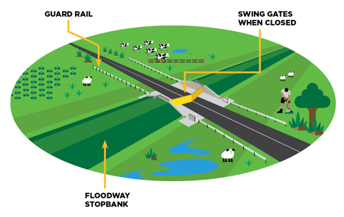
The final stage of the Floodway is the installation of two sets of swing gates across two roads (McCracken and McLean) near Edgecumbe. To construct the gates, it involves cutting into the road to create a new concrete pad. They then set up two concrete walls at each site for the gates to attach to (the steel gates were made off-site by Page Macrae and were brought in when the concrete work was done).
The design of this swing gate system is unique to New Zealand – while stoplogs and sliding gates are commonplace, hinged gates across a road are the first of their kind.
In a flood event, these swing gates will act as a barrier on the road, keeping cars from entering a flood zone, and maintain the stopbank height of the Floodway, creating a channel that will help send water out to the Rangitāiki River mouth.
Sub-contractor Tim Walters (Te Arawa) has worked with Paul on both Kaituna and Rangitāiki River projects, along with his brothers, Justin and Tom, cousin Kaia and neighbour TK. The Maketū local had been working in Australia on form work construction and returned home to New Zealand in 2018. He met Paul when he was recruiting local iwi to be involved in the Kaituna Mole construction.
“We had about six of us from Maketū get involved, all with different levels of experience, which was good as we could help build up the younger fellas.
“Being from Maketū it was a project I wanted to be part of, so I could go down there with my son and tell him, ‘Yeah, I built this’.”
When Paul secured the contract for the Rangitāiki job, he gave Tim a call to come and carry on working together. While it’s 40 minutes away from Tim’s home, it’s like another home to him, as his partner and her whānau have strong connections to the area.
“Her grandfather was Bill Kerrison, the ‘kaitiaki of tuna’ in the East, so although this is a different site, the Bay of Plenty is a small community where everyone knows everyone.
“For me and the other guys working on the site, it feels special to be part of these kinds of projects when you know what the purpose of it is – to help protect the people. We really enjoy it.”
Tim says there are plenty of advantages when it comes to locals working on local projects, particularly the pride that is put into them.
“Bringing in people who know the area, who know the people, is important. It gives the community peace of mind about who is working in their backyard as they know they will respect the place that they are working in.
“It’s also a great way to get the word out what’s happening, and encourage other locals to get involved and employed on these jobs.”
Paul says he is really enjoying the Rangitāiki project and he’s got a great team around him.
“Our crew have gelled together really well and we really enjoy working with Regional Council. The boys (Jordan and Peter) are straight-up when it comes to supporting local business and we’ve built a really good relationship.”
Bay of Plenty Regional Council received $10.28M for the Rangitāiki Floodway and Spillway, and $1.63M for the Kaituna Mole from Kānoa.
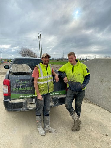
Tim Walters and Harry Thomson from Romanes Construction at the McCracken Road swing gate site.
A YEAR AGO
Council approves construction of proposed Rangitāiki Spillway design
Bay of Plenty Regional Council Councillors have approved increase in budget for the construction of the Rangitāiki Spillway, following overwhelming support from the community.
2023-05-10 Council approves construction of proposed Rangitāiki Spillway design
Bay of Plenty Regional Council Councillors have approved increase in budget for the construction of the Rangitāiki Spillway, following overwhelming support from the community.
In an event, the Spillway enables water from the Rangitāiki River to pass over a fixed crest weir (lowered, concrete-covered stopbank) and into the Floodway. This will help divert water away from the Rangitāiki River and reduce the risk of significant flood damage to both rural and urban areas.
2 YEARS AGO
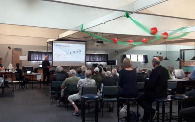
Community session to be held in Edgecumbe to discuss the Rangitāiki Spillway
Bay of Plenty Regional Council is holding a community session in Edgecumbe to discuss the Rangitāiki Spillway project.
2023-03-31 Community session to be held in Edgecumbe to discuss the Rangitāiki Spillway
Bay of Plenty Regional Council is holding a community session in Edgecumbe to discuss the Rangitāiki Spillway project.
The Spillway needs to be upgraded as it is part of the Rangitāiki Floodway, a key piece of flood defence infrastructure to help protect the community in a flood event.
In an event, the Floodway and Spillway upgrades will help divert water away from the Rangitāiki River. This helps reduce the risk of significant flood damage to both rural and urban areas (for example, the economic damage of the 2017 event was estimated to be $95M).
Engineering Manager Mark Townsend says since Regional Council last consulted with the community on the project in 2020, the estimated cost to upgrade the Spillway has increased.
The purpose of the community session is to have a conversation about why that is, how it will affect ratepayers and what the options are in a challenging economic climate.
“High inflation, rising interest rates, Covid-19 and high labour costs have led to price hikes across all sector, including construction.”
He adds that during the detail design phase of the project, river modelling and ground investigations identified key risks that needed to be addressed.
“These risks were seepage and erodibility (scour) of the structures when the Spillway is in operation, as well as a need to create certainty that the Spillway would achieve the required flows into the Floodway.
“Since meeting with the community in 2020, the Spillway has been designed to address these issues, better manage water flows over the Spillway and give the community reassurance that it will perform as required. These design changes include additional concrete work, sheet piling around the structure for seepage control, drainage and paddock contouring.”
The current estimate to construct the revised design in its entirety is $7.8M (less $2.1M of central government funding), a $5M increase from the original estimate ($2.8M). The increased costs will be passed on to ratepayers via targeted rates.
The community session is being held on Saturday 15 April from 10.30am to 12.30pm at the Edgecumbe War Memorial Hall (corner of Kauri Street and Main Street), Edgecumbe.
2022-12-15 Construction update: Disruption on McCracken and McLean Roads
Bay of Plenty Regional Council will begin construction for the final stage of the Rangitāiki Floodway from Monday 1 May 2023.
The Rangitāiki Floodway is a key piece of flood defence infrastructure to help protect the lives and livelihoods of the community.
In a flood event, the Rangitāiki Floodway is designed to take pressure off the Rangitāiki River by diverting some of its flow (via a Spillway) into near-by farmland between stopbanks and out the Rangitāiki River mouth at Thornton.
What’s happening?
The construction process involves installing swing gates (heavy duty steel flood barriers) at two sites along the Rangitāiki Floodway:
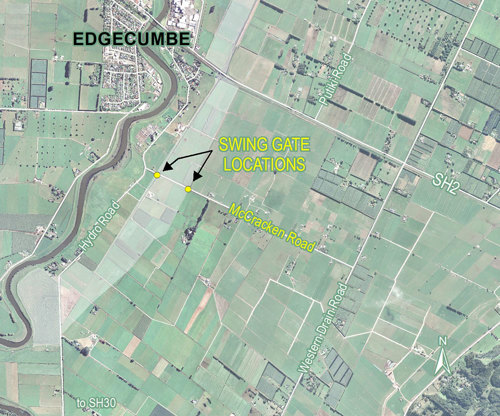
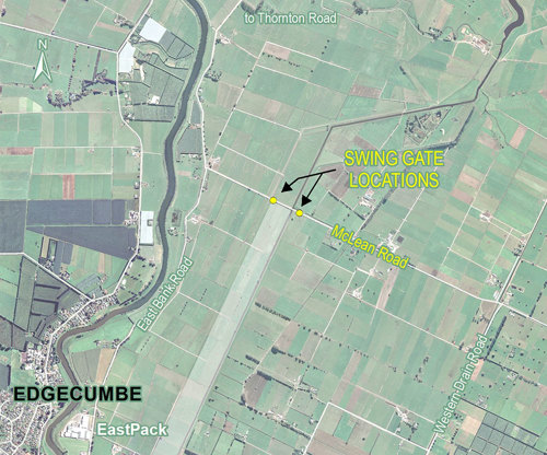
Site one: Two sets on McCracken Road (located between Hydro Road and Western Drain Road, Edgecumbe)
Site two: Two sets on McLean Road (located between East Bank Road and Western Drain Road, Edgecumbe).
When the Floodway is activated, these swing gates will have two functions: They will act as a barrier on the road, keeping the community from entering a flood zone, and maintain the stopbank height of the Floodway, creating a channel that helps send water out to the Rangitāiki River mouth.
When not in use, the gates are locked open, allowing uninterrupted traffic flow.
How might this impact you?
Construction is due to begin from Monday 1 May 2023 and each site is expected to take approximately seven weeks.
During construction, road closures will be in place around the swing gate site and there will be no through traffic. Residents will be able to access their homes, however detours will be in place to travel to and from McLean and McCracken Roads.
We will keep you updated on construction and road closures via this project page.
If you have any questions or concerns, please contact Project Lead Niroy Sumeran on engineering@boprc.govt.nz or 0800 884 880.
Thank you for your patience during this time.
2 YEARS AGO
Regional Council applies for variation to Spillway consent
Bay of Plenty Regional Council have made the commitment to publicly notify the variation to the resource consent application, for the construction and operation of the Spillway (located at 266 Hydro Road, Edgecumbe).
2022-10-06 Regional Council applies for variation to Spillway consent
Bay of Plenty Regional Council have made the commitment to publicly notify the variation to the resource consent application, for the construction and operation of the Spillway (located at 266 Hydro Road, Edgecumbe).
While consent was first granted in 2009, we are reapplying for consent as the design of the Spillway has changed to enable greater certainty of its operation in a flood event.
The original Spillway design was utilising a reinforced earth stopbank (fixed crest weir) and an inflatable rubber dam (a rubber, cylinder-shaped balloon that can be inflated and deflated to control the water flow into the Spillway).
Since obtaining that original consent, we have determined that the consented Spillway design would not be the most suitable or reliable option.
There are a few reasons why we are publicly notifying the community about our reapplication:
The Spillway design has changed. This new application is seeking approval to change the current approved Spillway design to a lower fixed crest weir structure (a lower level stopbank capped with concrete). We are also adding three contingency gates as back-up.
In the new proposed design, the Spillway will ‘activate’ at a lower river flow threshold, meaning that water may run into the Spillway and Floodway more frequently. This provides greater certainty around operation in a flood event.
Significant earthworks are required to create the new Spillway design and paddock contouring downstream of the Spillway is required to channel water into the Floodway.
We have made a commitment to keep the community informed with progress to this project as it is of public interest and a key piece of infrastructure to help protect the community.
We’re two thirds of the way through the floodwall replacements with the Greig Road and East Bank Road walls now complete.
Watch this video to see all the progress we’ve made this year:
2021-12-14 End of year floodwall project wrap
3 YEARS AGO
Work recommencing on Rangitāiki Floodway
We are recommencing work on the Rangitāiki Floodway project on the outskirts of Edgecumbe in the section located between SH2 and Mclean’s Road.
Please take extra care on the roads around the site, we’ll be taking extra care too.
We're doing this work to improve how water travels down the floodway which will reduce the pressure on the Rangitāiki River stopbanks during large flood events.
2021-11-15 Work recommencing on Rangitāiki Floodway
We are recommencing work on the Rangitāiki Floodway project on the outskirts of Edgecumbe in the section located between SH2 and Mclean’s Road.
Please take extra care on the roads around the site, we’ll be taking extra care too.
We're doing this work to improve how water travels down the floodway which will reduce the pressure on the Rangitāiki River stopbanks during large flood events.
3 YEARS AGO
Construction of Stage 6c underway
Construction of Stage 6c of the Rangitāiki Floodway is underway after resource consent was granted.
Construction of Stage 6c of the Rangitāiki Floodway is underway after resource consent was granted.
This stage will see 3km of the right stopbank raised and has been split into two sections.
For the initial section, stockpiled construction earthfill will be transported from our storage site at the State Highway 2 end to halfway down the stopbank for construction. Contractors will then work back towards State Highway 2.
There is a temporary speed restriction of 50km/h (as identified on the map above) on State Highway 2 as trucks will be turning onto site.
We are hoping to complete to this section before July 2021, weather permitting.
We will then have to stop the project over winter, and will begin raising the second half of the right stopbank later in the year.
We’re doing this work to improve how water travels down the Rangitāiki Floodway (Reids Central Canal), which will in turn reduce the pressure on the Rangitāiki River stopbanks during large flood events.
Detailed modelling is continuing to feed into the final design of the spillway.
4 YEARS AGO
Rangitāiki Floodway Project update
The summer construction season is in full swing with steady progress being made on raising the stopbanks as part of the Rangitāiki Floodway Project.
The summer construction season is in full swing with steady progress being made on raising the stopbanks as part of the Rangitāiki Floodway Project.
Earthworks for Stage 6a involved raising the left stopbank of the floodway north of McLean Road. Fencing and grass reinstatement will see this stage completed by the end of March.
Work continues on Stage 6b with the raising of the left stopbank from McLean Road to State Highway 2. This stage has a likely completion timeframe of May/June.
Preparation works on the opposite right stopbank (6c) started in early February, while the earthworks resource consent for this stage is still pending.
Two thirds of the work on raising the stopbank for Stage 7 (between Hydro Road and SH2) was completed last year with the final section to be finished by June.
Thank you to those who were able to take part in the recent online consultation about the next stages of the Rangitāiki Floodway Project.
Now that COVID-19 alert levels have eased, Council is inviting anyone with an interest in the Rangitāiki Floodway to another opportunity to learn more, and tell us what you think, about Stage 6 and the preferred spillway design.
Some aspects of the these stages have changed, so this consultation will explain the reasons; the relating cost increases and the potential rating impacts.
If you live within the Rangitāiki-Tarawera catchment, it’s important to find out more, and have your say.
Previously a ponding option downstream of Fonterra was being looked at to reduce the overall project costs. This option has now been abandoned.
This is because detailed design showed that this option was in fact going to be a more expensive option and the benefits were not as great as originally assessed.
Consequently the stopbank raising option is now the preferred option. The detailed design also showed that for all options the scale of work required had been under represented in previous modelling results.
Due to the above, Stage 7 of the Rangitāiki Floodway was brought forward to be completed before Stage 6.
The reason for this is that Stage 6 is a far more complex stage and more time was needed to complete the detailed design and geotechnical testing to inform the final design.
The final estimate for Stage 6 has now been produced and is shown in table 1 below:
Stage
LTP Cost Estimate (000)
Updated Estimate (000)
Difference (000)
6
$ 2,428
$ 10,915
$8,497
Rangitāiki Floodway Spillway
During 2018 consultation was undertaken within the local community on options for the spillway design. The proposed option was for a lower fixed crest weir with contingency radial gates and was generally supported at the culmination of the consultation on 24th November 2018.
The option that had been prepared prior to this consultation taking place in the Long Term Plan (LTP) was for a lower fixed crest weir with no contingency allowance.
Table 2 below shows the increase in cost for the Spillway.
Stage
LTP Cost Estimate – Lower Fixed Crest Weir (000)
Lower Fixed Crest Weir with contingency gates (000)
Spillway
$ 0.360
$ 2,800
Crown Infrastructure Partners (CIP) funding
Central Government announced that it wants to help with economic recovery once we are out of the Covid 19 restrictions. We have put the Rangitāiki Floodway project up as a “spade ready” project that Central Government could help fund. If successful, the increased costs outlined above could be off-set by the CIP funding.
2020-01-28 Stage 7 of the Rangitaiki Floodway Upgrade Project
We’re about to begin Stage 7 of the Rangitāiki Floodway Upgrade Project – the section from Hydro Road to State Highway 2.
We’re doing this work to improve how water travels down the Rangitāiki Floodway (Reids Central Canal), which will in turn reduce the pressure on the Rangitāiki River stopbanks during large flood events. Construction works will begin in January 2020 and are expected to be completed in June 2020 but are weather dependant. We’ll keep you informed if these dates change or work goes longer than expected.
If you have further questions, please call 0800 884 880 to speak to a staff member about the project.
5 YEARS AGO
New bridge at Thornton
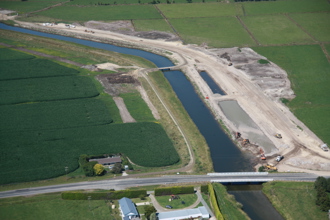
Stage 5 of the Rangitāiki Floodway Project has reached a significant milestone with bridge construction nearing completion on Thornton Hall Road near Whakatāne.
Stage 5 of the Rangitāiki Floodway Project has reached a significant milestone with bridge construction nearing completion on Thornton Hall Road near Whakatāne.
The Rangitāiki Floodway Project is being built in stages to take pressure off the flood-prone Rangitāiki River. The current work, which started in late February this year, has seen the construction of a bifurcation channel and the upgrading of Thornton Hall Road, including the new bridge.
Project Manager for Stage 5, Bay of Plenty Regional Council’s Civil Construction Engineer, Jordan Mandery says local residents will see a few final works in the area before the current stage is complete.
“Getting the bridge in place is a significant milestone. We have the bridge beams on, so now we can complete the abutments and bridge approach. We expect the subbase layers of the road construction to get underway shortly and be completed by the end of October. At that point we can divert traffic across the bridge and remove the final piece of land and open the bifurcation channel,” Mr Mandery explains.
Activity around Thornton Hall Road has bound together several other improvements including upgrading the powerlines in conjunction with Horizon Energy and working with Whakatāne District Council to widen the road.
At the same time, a wetland has been created in the area where Reid’s Central Canal will meet the Rangitaiki River. Regional Council’s Land Management team has overseen initial plantings, with more scheduled once the bifurcation is open.
“I’d like to thank the residents and motorists for their cooperation and patience while these critical works are undertaken. Please continue to be considerate and follow the direction of the temporary traffic management while driving past the site as it is important for the safety of our contractors.”
“We are also looking to raise the section of stopbank alongside Thornton Road which is set out in our Long Term Plan, but we’ve decided to bring that forward while we are working in the area, so people will see that work taking place in coming weeks,” Mr Mandery said.
5 YEARS AGO
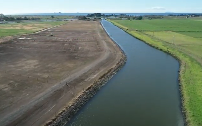
Floodway construction progress
Check out this short video of a recent drone flight over the completed Stage 4 works and the Stage 5 works currently in progress.
Check out this short video of a recent drone flight over the completed Stage 4 works and the Stage 5 works currently in progress.
Stage 5 involves creating a bifurcation cut to connect the Rangitāiki Floodway with the Rangitāiki River, as well as building a bridge over the new bifurcation and undertaking stopbank overlay works along Thornton Hall Road. A wetland is also being created to help encourage wildlife into the area. These works are expected to be completed in September 2019 and we hope you will share the journey with us as we post regular updates of the works progress.
5 YEARS AGO
Drone survey taking place next week
The Bay of Plenty Regional Council will be undertaking a drone survey of sections of the Rangitāiki Floodway during the week of 13 – 17 May to provide council engineers with a Digital Elevation Model (DEM) which will feed into the design for Stage 7 of the Floodway Project.
The Bay of Plenty Regional Council will be undertaking a drone survey of sections of the Rangitāiki Floodway during the week of 13 – 17 May to provide council engineers with a Digital Elevation Model (DEM) which will feed into the design for Stage 7 of the Floodway Project.
The data being collected is high resolution aerial photography used for photogrammetric modelling purposes and will be used for internal purposes only. The survey will be carried out by Regional Council engineers who will be wearing Hi-Vis clothing and will be in a branded Bay of Plenty Regional Council vehicle. Please feel free to approach them on the day should you have any questions.
6 YEARS AGO
Bridge and bifurcation works get on the road
Initial site preparation works started on Monday 25 February on the Reid’s Canal bifurcation which is Stage 5 of the multi-stage Rangitāiki Floodway Upgrade Project commenced in 2011.
2019-02-26 Bridge and bifurcation works get on the road
Initial site preparation works started on Monday 25 February on the Reid’s Canal bifurcation which is Stage 5 of the multi-stage Rangitāiki Floodway Upgrade Project commenced in 2011.
The purpose of this stage is to create a bifurcation cut from the left bank of Reid’s Central Canal across Thornton Hall Road to provide a second outlet into the Rangitaiki River and out through the river mouth. These works, which are expected to be completed within six months, also include road alignment works and a new bridge to carry Thornton Hall Road over the new canal outlet.
6 YEARS AGO
Karakia held in preparation for Stage 5
Following selection of the successful tenderer for the Rangitāiki Floodway Stage 5 works, a karakia ceremony was held at the Reid’s Canal bifurcation with the Rangitāiki River on Monday 18 February with representatives of Ngāi Taiwhakaea, the works contractor, the project’s archaeology advisor and the Bay of Plenty Regional Council in attendance.
2019-02-19 Karakia held in preparation for Stage 5
6 YEARS AGO
Spillway recommendation presented at Edgecumbe information session
Around 40 interested community members, representing a number of stakeholder groups, turned out on Saturday to hear an update on the consultation process for the upgrade of the Rangitāiki Spillway.
2018-12-07 Spillway recommendation presented at Edgecumbe information session
Around 40 interested community members, representing a number of stakeholder groups, turned out on Saturday to hear an update on the consultation process for the upgrade of the Rangitāiki Spillway.
The spillway – the mechanism to divert floodwater from the river into the Floodway - is planned for upgrade in 2020/21 and in recent months Council’s engineering team has been engaging with directly affected landowners and the wider community around the options for the spillway design.
6 YEARS AGO
Rangitāiki Floodway information session
Thank you to those people who have been involved in finding out about the options for the design of the Rangitāiki Floodway spillway and potential ponding areas.
On Saturday, 24 November, starting at 10am there will be a further information session at the Rangitāiki Cosmopolitan Club to inform interested parties about the preferred option that will be put to Council in December.
We will be asking those attending to give an indication of their level of support for the proposed option.
For further information, please email engineering@boprc.govt.nz
2018-11-08 Rangitāiki Floodway information session
Thank you to those people who have been involved in finding out about the options for the design of the Rangitāiki Floodway spillway and potential ponding areas.
On Saturday, 24 November, starting at 10am there will be a further information session at the Rangitāiki Cosmopolitan Club to inform interested parties about the preferred option that will be put to Council in December.
We will be asking those attending to give an indication of their level of support for the proposed option.
For further information, please email engineering@boprc.govt.nz
6 YEARS AGO
Rangitāiki Floodway Stage 4 recommences
Drier spring weather has allowed the work to start again on Stage 4 of the Rangitāiki Floodway Upgrade Project after it was put on hold over winter.
Meanwhile, consultation with affected landowners and the wider community over the design options to upgrade the spillway section of the Floodway is in its final stages before a recommendation is made to Council on the preferred option (lower fixed crest weir or inflatable rubber dam). The spillway is the structure that diverts floodwater from the Rangitāiki River into the floodway and its construction and associated stopbank widening will be the final stage of the project. Keep an eye on this page for publication of an information session planned for mid-November 2018.
6 YEARS AGO
Rangitāiki Spillway site visit held in August 2018
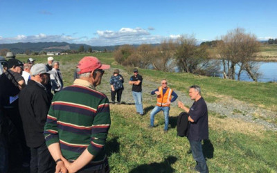
As part of the consultation underway on the Rangitāiki Spillway, a site visit was held in Edgecumbe on 11 August this year, with over 30 people attending, including residents of property adjoining the floodway and interested members of the community.
2018-08-14 Rangitāiki Spillway site visit held in August 2018
As part of the consultation underway on the Rangitāiki Spillway, a site visit was held in Edgecumbe on 11 August this year, with over 30 people attending, including residents of property adjoining the floodway and interested members of the community.
Those who came along on the bus trip out to the spillway off Hydro Road appreciated the chance to see the current spillway up close and hear about the options available. Once the preferred option is confirmed by Regional Council, it will go through a consent process. Construction is anticipated to start in 2020. The spillway construction will mark the final stage in this multi-stage project.
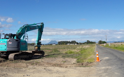
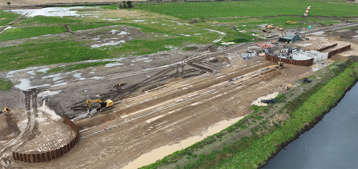 Construction of the spillway (July 2024).