Volcanic hazards
The Bay of Plenty contains five active volcanic areas:
- Ōkataina Volcanic Centre
- Tūhua (Mayor Island)
- Whakaari (White Island)
- Pūtauaki (Mount Edgecumbe)
- Rotorua Caldera
These locations (with the exception of Tūhua) sit within the larger Taupō Volcanic Zone (TVZ) which stretches 350km from Mount Ruapehu on the Central Plateau to Whakaari off the east coast of the Bay of Plenty. Most New Zealand volcanic activity in the last 1.6 million years has occurred in the Taupō Volcanic Zone.
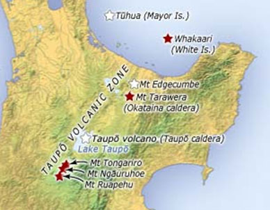
Image reproduced courtesy of Te Ara The Encyclopedia of New Zealand.
Ōkataina Volcanic Centre
The Ōkataina Volcanic Centre is a large volcanic caldera which collapsed approximately 64,000 years ago and covers an area of around 450 square kilometres. A caldera is a large depression formed when a volcano erupts and collapses. The area is a complex mix of over 30 active vents lying between Rotorua and Kawerau and includes volcanoes which have formed since the caldera collapse such as Mount Tarawera. The area last erupted in 1886 destroying the world famous pink and white terraces.
Tūhua (Mayor Island)
Tūhua is a marine volcano and lies 35 kilometres north of Tauranga. It has erupted on average once every 3,000 years for the past 130,000 years with its most recent eruption possibly being less than 1,000 years ago. Since human arrival in New Zealand, no activity or unrest is known to have occurred.
Whakaari (White Island)
Another marine volcano, Whakaari lies 48 kilometres from the coast and has been in an almost constant state of volcanic gas release since it was sighted by James Cook in 1769. Whakaari erupted continually from December 1975 until September 2000 and has also erupted in 2012, 2016 and 2019.
Pūtauaki (Mount Edgecumbe)
Pūtauaki is a relatively young volcano situated 3km east of Kawerau. Evidence suggests that the cone has grown mostly over the last 5,000 years with recent eruptions being 2,300 – 3,000 years ago.
Rotorua Caldera
The Rotorua Caldera formed around 240,000 years ago with a large portion of it now filled by Lake Rotorua. Rotorua city itself is located within the caldera along with geothermally active areas such as Tikitere and Whakarewarewa. It is unknown when the most recent eruption occurred but it is believed to be over 20,000 years ago
Volcanic activity
Several hazards may affect the area immediately around a volcano, such as lava flows, pyroclastic flows, lahars, landslides and debris flows. Volcanic activity also produces hazards that can affect areas far from the volcano, such as ashfall.
This range in eruption size and occurrence can make planning for volcanic activity problematic.
Constant hazards:
|
Close to volcano:
|
Away from volcano:
|
 Ashfall
 Gases
Gases Lahars
 Ballistics
 Lava flows
 Pyroclastic flows
 Debris avalanches
What does this mean for the Bay of Plenty region?
All five of the volcanic areas in our region have different eruption profiles. While Tūhua and Whakaari are likely to impact only on themselves, the Ōkataina Volcanic Centre, Pūtauaki and the Rotorua Caldera would affect the mainland of New Zealand with the dominant effect on the Bay of Plenty region likely to be ashfall.
The Bay of Plenty Regional Council has recently undertaken a volcanic hazards scoping study for the region to develop recommendations concerning volcanic hazard risk assessment and volcanic susceptibility mapping. This study will be used to build a picture of volcanic risk in the Bay of Plenty and to inform future mapping and risk assessment work.