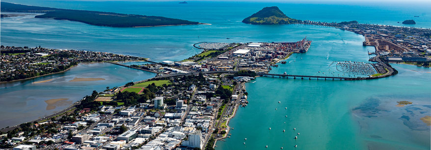
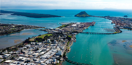
Tauranga Harbour
Te Awanui or Tauranga Harbour, is a regional treasure. It is one of New Zealand's largest natural harbours and is home to the country's biggest export port, the port of Tauranga.
The name 'Tauranga' means 'landing place'.
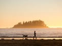
Hundreds of people, locals and visitors alike, use the harbour everyday, for strolling along beaches, watching birds, fishing, boating or burning off some energy surfing or kite boarding within its sheltered, clear waters.
Tauranga Harbour is a large tidal estuary covering an area of 218 square kilometres. To drive from one end of the harbour to the other takes about one hour and covers more than 60 kilometres. At the eastern end of the harbour is the landmark Mauao (Mount Maunganui) and the city of Tauranga.
This entrance is deeper and allows for a large number of cargo ships to enter and leave the Port of Tauranga. At the western end is the small coastal settlement of Otāwhiwhi or Bowentown. This entrance is shallower but is often used by recreational boaties.
The harbour catchment
Tauranga Harbour extends beyond simply where the land meets the sea. It covers an area of almost 1,300 square kilometres and contains 27 major rivers and 46 minor streams. It also includes the city of Tauranga, and extensive horticultural and agricultural areas. It starts from Pāpāmoa in the south, runs along the Kaimai Mamaku ranges and extends to Orokawa Bay, north of Waihī Beach. It also includes Matakana Island and Te Awanui Tauranga Harbour, which alone covers an area of 210 square kilometers and is home to one of New Zealand’s largest estuaries. The entire harbour has also been identified as an outstanding natural feature and landscape.
The surrounding land from which water runs into the harbour is used extensively for urban, horticultural and agricultural purposes. The Tauranga area is one of New Zealand's fastest growing residential areas. The climate of the area provides ideal conditions for growing fruit such as kiwifruit and avocados. There is also land in the catchment that is ideal for sheep and cattle grazing.
Tangata Whenua of Tauranga Moana
He aha ra tera e whakakarekare mai ra i a Te Awanui, he matangi, he matangi, he matangi mariri ke
Whatever is that creating ripples on Te Awanui, a breeze, a breeze, an especially gentle breeze.
Tauranga Harbour is a physical and spiritual symbol of identity for all whanau, hapū and iwi living in the area.
Ngāti Ranginui
Ngāti Ranginui are the descendants of ancestors who arrived on the Takitimu Waka and settled in Tauranga Moana. Over many generations, these ancestors and their descendants established villages, fortifications, burial grounds, fishing areas and forest places. Ngāti Ranginui has 10 affiliated hapū and marae, located between Katikati and Waimapu.
Ngāi Te Rangi
Ngāi Te Rangi is a Mataatua tribe, with a rich history which began from our journeys from the East Coast. After many battles, Ngāi Te Rangi resided in Whangarā, then Opotiki, and through intermarriage and many gruelling battles, finally settled in Tauranga Moana. This historical journey is known as Te Heke o Rangihouhiri.
Ngāi Te Rangi have 11 operative Marae and 11 affiliated Hapu located as far north as Katikati through to Te Tumu in the east and on the islands of Matakana, Tuhua, Motiti and Rangiwaea. It is the largest of the three Iwi that have settled in the Tauranga Moana.
Ngāti Pūkenga
Ngāti Pūkenga is a Mataatua tribe, comprising the descendants of Te Tāwera, Ngāti Ha and Ngāti Pūkenga. Their customary lands are located at four dispersed kāinga – Tauranga, Maketu, Manaia and Pakikaikutu. Ngati Pūkenga have eight affiliated hapū and two marae, located at Welcome Bay and the Coromandel.


History
Historians tell us that Māori first landed around the 12th Century. This was the Takitimu and Mataatua waka, from which the iwi of Ngāti Ranginui (Takitimu), Ngaiterangi, Ngati Pukenga (both Mataatua) and their associated hapū are descended. Hauraki iwi, from the Tainui waka, also claim an interest in the northern harbour catchment.
Te Awanui was once the means of access and communication among the various whanau, hapū and iwi, around its shores and still is the source of kaimoana. Today there are 24 marae in and around Tauranga Moana (Te Awanui).
It should also be noted that not all Māori currently living in and around Tauranga are tangata whenua. This group with tribal links elsewhere in New Zealand are known as taura here (rope linkages) or rawaho (outsiders).
Matakana Island
Largely covered by pine plantations for forestry, Matakana Island forms a natural barrier between the harbour and the Pacific Ocean. Matakana Island is also home to a number of people who live in the island's settlement who are mainly Tangata Whenua and have lived here for generations. The sheltered side of the island has inlets and lagoons and the ocean side of the island with its white sandy beaches and rolling surf is popular with local surfers.
Tidal waters
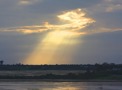
The harbour waters are mostly shallow. At low tide more than 60 percent of the harbour bed is exposed. The estuaries of Tauranga Harbour are home to many kinds of wildlife. Young fish spawn in the shallow waters and many birds nest on the harbour margins. A large volume of water enters and leaves the harbour with each tide.
Valuable resource
The harbour has long been an important resource for the people of the Bay of Plenty. For Māori, the harbour has strong spiritual significance and is a traditional source of food. Flounder, kahawai, mussels and cockles are some of the kaimoana (seafood) that can be collected from the harbour. There are often limits as to how much can be collected and where they can be collected from.
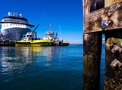
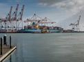
Commercial activity
Commercial activity revolves around the Port of Tauranga which operates several kilometres of wharves on land which has been reclaimed from the harbour at Sulphur Point and at Mount Maunganui. Established in 1873, the port handles more export cargo than any other port in the country, with more than 2000 ship movements in and out of the harbour every year.
A range of different goods come in and out of the port including logs, cement, grain, steel, vehicles, dairy products and kiwifruit.
Wildlife and natural heritage
Kei te rererere nga manu - The birds are flying about
This simple proverb reminds us that when the birds are flying - it is safe. At the slightest sign of danger the birds stop flying and seek refuge. We want Tauranga Harbour to be a safe place for our birds, and all the other flora and fauna that live in it.
Tauranga Harbour is truly unique and its varying landscape means it is home to a wide range of species that have adapted and thrived in the different landscapes there are, from the mountains to the sea.
We work with community care groups and other organisations to ensure that our Harbour is a safe, healthy environment for all living species.
Tauranga Harbour is home to many birds. Some birds nest and feed in the harbour and others migrate from different places.
Some of the birds found in Tauranga Harbour include:
- Bittern
- Spotless Crake
- Dabchick
- New Zealand Dotterel
- Fernbird
- Bar-tailed Godwit
- Black and Red-billed Gulls
- White-faced Heron
- Variable Oystercatcher
- Banded Rail
- Pied Shag
- Royal Spoonbill
- Pied Stilt
- Caspian Tern
- Wrybill
- Pukeko
Estuary life
Tauranga Harbour's estuaries are full of life. They are the breeding grounds for some species and the feeding grounds for others. Some of the species in our Harbour include:
- Flounder
- Whitebait
- Kahawai
- Herring
- Eels
- Crabs
- Clams
- Shellfish
- Heart urchins
- Snails
- Worms
Tourism
Each year the Port sees cruise ships from the Pacific Islands, North America and Europe pass through the Tauranga Harbour. These ships bring large numbers of tourists into the Bay which in turn is great for the local and NZ economy.
There are a number of tourist activities that take place on or leave from Tauranga Harbour. Some of these include:
- Fishing charters
- Harbour cruises
- Wind surfing
- Catamaran hire
- Sea-kayaking
There are two main marinas on the harbour:
- Sulphur Point Marina
- Tauranga Bridge Marina
Land management around Tauranga harbour
The Regional Natural Resource Plan governs earthworks for land development through the resource consent process, which places requirements to control sediment run-off. A review of the management rules and practices dealing with sediment generating activities is planned.
Land management programmes run by Council, such as fencing of stream margins around the harbour, revegetation of steep land, and farm environment plans are important in reducing the amount of sediment entering the harbour. Coupled with the work of Estuary Care groups around the harbour, improved land management plays an important role in reversing the effects sedimentation.
More information