Liquefaction
Liquefaction happens when the energy from an earthquake increases ground water pressure, causing soil to lose strength and temporarily behave like a liquid.
This specifically relates to soil that is below the groundwater table and is sandy or silty. Liquefaction can be made worse by rising ground water levels as a result of climate change.
Liquefaction damage was reported in the eastern Bay of Plenty after the Edgecumbe earthquake in 1987. It caused 10 million dollars of damage to drainage and flood control assets alone.
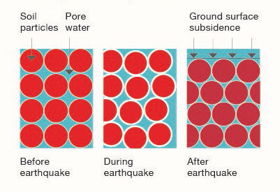
The liquefaction process
Before the earthquake
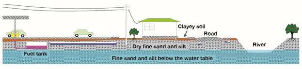
Areas of flat, low lying land with groundwater only a few meters below the surface can support buildings and roads, buried pipes, cables and tanks under normal conditions.
During and after the earthquake
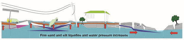
During the earthquake, fine sand, silt and water move up under pressure through cracks and other weak areas to erupt on to the ground surface. Near rivers the pressure is relieved to the side as the ground moves sideways into the river channels.
Ground effects:
- Sand boils (sand volcanoes)
Sand, silt and water erupts upward under pressure through cracks and flows out onto the surface. - Lateral spreading
River banks flow toward each other. Cracks open along the banks. Cracking can extend back into properties, damaging houses. - Subsidence
Land re-consolidates after the event at a lower level than before. This is called subsidence. Subsidence can be uneven resulting in ground cracking and distortion, which can cause damage to buildings and infrastructure.
Impacts on the built environment:
- Power poles are pulled over by their wires as they can't be supported in the liquefied ground.
- Underground cables are pulled apart.
- Tanks and pipes float up in the liquefied ground and break through the surface.
- Pipes can break and sewage leaks into the ground.
- Heavy objects like cars can sink into the ground.
- Buildings develop cracks and can become unsafe.
What does liquefaction mean for the Bay of Plenty?
The Bay of Plenty Regional Council commissioned experts to assess the potential liquefaction vulnerability across the region.
The assessment followed national guidelines for mapping liquefaction at a regional scale. The Earthquake Commission (EQC), the Ministry of Business, Innovation & Employment (MBIE) and the Ministry for the Environment (MfE) have published a guidance document Planning & Engineering Guidance for Potentially Liquefaction-Prone Land (2017). This document sets out guidelines regarding guidelines regarding liquefaction vulnerability assessment and mapping.
The assessment classifies and maps the land as one of three liquefaction categories:
- Liquefaction Damage is Unlikely
- Liquefaction Damage is Possible
- Liquefaction Category is Undetermined
Where can I view these maps?
The Bay of Plenty regional liquefaction maps are available at BayHazards.
Bay of Plenty Region Liquefaction Hazard Assessment Scoping Study
Bay of Plenty Regional Liquefaction Vulnerability Assessment
BOPRC completed a further liquefaction assessment for the new Ōmokoroa urban growth area in partnership with Western Bay of Plenty District Council.