
Managing our geothermal systems
Bay of Plenty Regional Council is responsible for managing the sustainable use of geothermal in our region.
This includes:
- The development of policy to guide use of geothermal
- Allocation of geothermal heat and fluid through resource consents
- Monitoring to measure the health of the resource
- Classifying geothermal systems to determine the management purpose for each system
Planning provisions
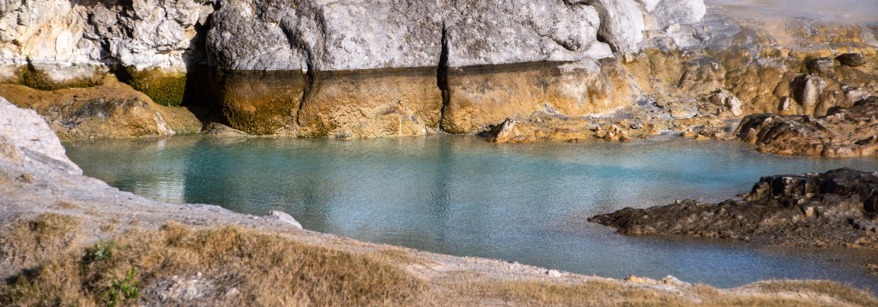
The Regional Policy Statement sets the overall direction for sustainable geothermal management through objectives and policies. It classifies geothermal systems and requires protection of significant geothermal features. The relationship of Māori and their culture and traditions related to geothermal must also be recognised and provided for.
Regional plans give effect to the Regional Policy Statement and set the rules for use of the resource. Geothermal provisions are currently in the Regional Natural Resources Plan and the Rotorua Geothermal Regional Plan. These are currently under review.
Regional plans include policies and rules on activities, allocation limits, and things that must be considered in resource consent applications.
System Management Plans
The Regional Policy Statement requires the development of system management plans for Development Systems or for systems with a high level of use. In our Region this includes Rotorua, Kawerau and Tauranga systems.
The content for a system management plan is set out in the Regional Policy Statement. A System Management Plan (SMP) looks at a geothermal system in an integrated way, and includes objectives for its overall management and strategies to achieve the objectives. However, there is no set template, and it may take on varied forms and include additional information as suits the system to be managed.
For Rotorua and Tauranga the content included in the system management plan will form the basis for changes to the geothermal provisions of the Regional Natural Resources Plan. For other systems (e.g. Conditional Development Systems), the system management plan might form part of information submitted in support of resource consent applications.
A SMP has been developed for the Kawerau System, and SMPs for Rotorua and Tauranga are under development.
In April 2024, Toi Moana Bay of Plenty Regional Council approved the Rotorua Geothermal System Management Plan (SMP) Ngā Wai Ariki o Rotorua He Mahere Whakahaere Pūnaha, a ‘care plan’ and Regional Council policy that will guide the overall management of the Rotorua Geothermal System.
It will also be used to guide and inform changes to the Regional Natural Resources Plan (RNRP) and the Rotorua Geothermal Regional Plan (RGRP) later this year. These plan changes are part of a regular review process under the Resource Management Act (RMA) to make clear how the geothermal (ngāwha) resources in Rotorua city are to be used.
Resource consents
The RMA gives regional councils the role of managing the taking, use, damming and diversion of geothermal water, discharges of geothermal water and gas and the taking and use of geothermal energy (heat). Regional plans set out the rules for use:
For example, a resource consent (a permit to use) is required from the Regional Council to:
- construct a new geothermal well
- take geothermal water and energy
- take geothermal energy only
- To discharge of geothermal water by reinjection, or to surface environments
Decisions must consider the effects of that use on the system and other users, and on significant geothermal surface features and cultural values.
All our consent forms can be downloaded.
Customary uses
Low impact uses of geothermal by Māori have taken place over hundreds of years. Geothermal taonga is used for bathing, home heating, healing and cooking, and provides for the health and wellbeing of whanau, hapu and wider communities. It is part of everyday lives. The RMA protects the Treaty right of Māori to continue these customary practices. No consent is needed to use geothermal in accordance with tikanga Maori for the communal benefit of the tangata whenua of the area and does not have an adverse effect on the environment (RMA s14(3)(c).
Mātauranga/Knowledge/Monitoring and Research
Knowledge about geothermal is based on hundreds of years of observation by tangata whenua, and more recently by mainstream science such as geology, geochemistry and hydrology. This collective knowledge informs the way we manage geothermal and includes research, monitoring of the health of a system, and modelling of sustainable allocation limits. This differs for all systems, depending on how systems are used and how vulnerable they are to change.
For example, Rotorua system has a large number of resource users and is very sensitive to over use, so we monitor it closely. Our surface feature database is an important part of our state of the environment monitoring programme and includes bimonthly monitoring of 36 surface features in Rotorua. Other work includes measuring use through resource consents and monitoring water levels and temperatures over time in geothermal monitoring wells. We also continually build our knowledge of how the systems work (e.g. geology), climatic changes, and develop mathematical reservoir models to predict the effects of use and development
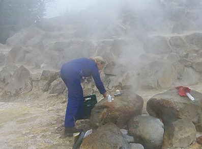 Modelling is also an important tool to manage the resource. Conceptual models are our current understanding of the physical features which control the flow of water and heat through the system (e.g. faults). Mathematical or numerical Reservoir Models provide quantitative estimates of the way water and energy might move through a system. We compare modelled predictions of the way the reservoir might behave in certain circumstances with our actual monitoring data and observations to guide our management decisions (e.g. from monitoring wells or surface features).
Our surface feature database is an important part of our state of the environment monitoring programme. Other work includes measuring use through resource consents and monitoring water levels and temperatures over time. We also continually build our knowledge of how the systems work (e.g. geology) and develop mathematical reservoir models to predict the effects of use and development.
Some other current and new work areas include:
- Maintaining and improving our database for geothermal surface features and mapping of these features.
- Developing and updating mathematical reservoir models.
- Supporting magneto telluric (MT) surveys (looking at deep resource).
- Thermal infrared mapping of surface features.
- Heat flow surveys.
- Supporting tangata whenua with Mātauranga Māori monitoring.
We collaborate with Waikato Regional Council on some science projects and work with science providers such as GNS to contribute to geothermal research. All of this information is used to guide decisions on consents, and policy direction such as allocation limits.
How you can be more efficient in your use of geothermal heat and water
We are always looking at ways to be more efficient in the way geothermal heat and water is allocated and used. This has become more important recently as our Rotorua geothermal monitoring wells are showing a decline in water levels. We think this is due to an extended dry period rather than any change in use. Whilst we cannot control the climate, we can control how much water and heat we are taking. The Rotorua Geothermal System Factsheet provides additional detail on the Rotorua geothermal system and advice on ways to be reduce waste and increase efficiency.
It is important to build geothermal wells to best practice standards and keeping them in good condition as uncontrolled or inefficient use can have adverse effects on the sustainability of the geothermal system. See Well safety for further information on this.
Science technical reports are available via the link below. Hardcopies are available from council on request.
Glossary and reports
View our glossary and reports page for more information and technical report documents.
For more information on our geothermal plans visit our Geothermal Plan Change page.