
Proposed Change 8 (NPS-HPL)
What is Proposed Change 8 (NPS-HPL)?
Bay of Plenty Regional Council Toi Moana is developing a change to the operative Bay of Plenty Regional Policy Statement (RPS) to implement the National Policy Statement on Highly Productive Land 2022 (NPS-HPL). This change is called Proposed Change 8 (NPS-HPL).
The NPS-HPL requires an RPS change to include maps identifying all highly productive land in the region. This must be publicly notified for submissions no later than 17 October 2025.
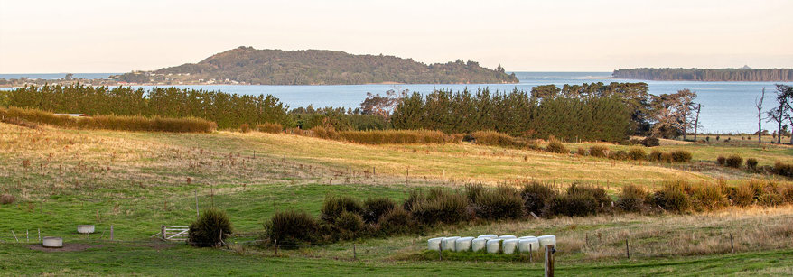
The NPS-HPL requires New Zealand’s most productive land is identified and protected by Regional Policy Statements and District Plans. This is to ensure that it is protected for ongoing use in land-based primary production while avoiding inappropriate subdivision, use and development. Land-based primary production means production from agricultural, pastoral, horticultural, or forestry activities, that is reliant on soil resource.
Bay of Plenty Regional Council will be preparing maps of highly productive land in the region for inclusion in the Bay of Plenty Regional Policy Statement (RPS).
In addition to mapping highly productive land in the RPS, Proposed Change 8 (NPS-HPL) will involve amending all ‘versatile land’ references to instead refer to ‘highly productive land’. Other amendments to the existing RPS rural growth management provisions may also be necessary to align with the NPS-HPL.
What do we mean by highly productive land?
Highly productive land has been mapped as Land Use Capability classes 1, 2 and 3 by the New Zealand Land Resource Inventory and has a rural production or general rural zone (in the relevant city or district plan). It excludes land that on 17 October 2022 was identified for future urban development or subject to a Council initiated, or an adopted, notified plan change to rezone it from general rural or rural production to urban or rural lifestyle.
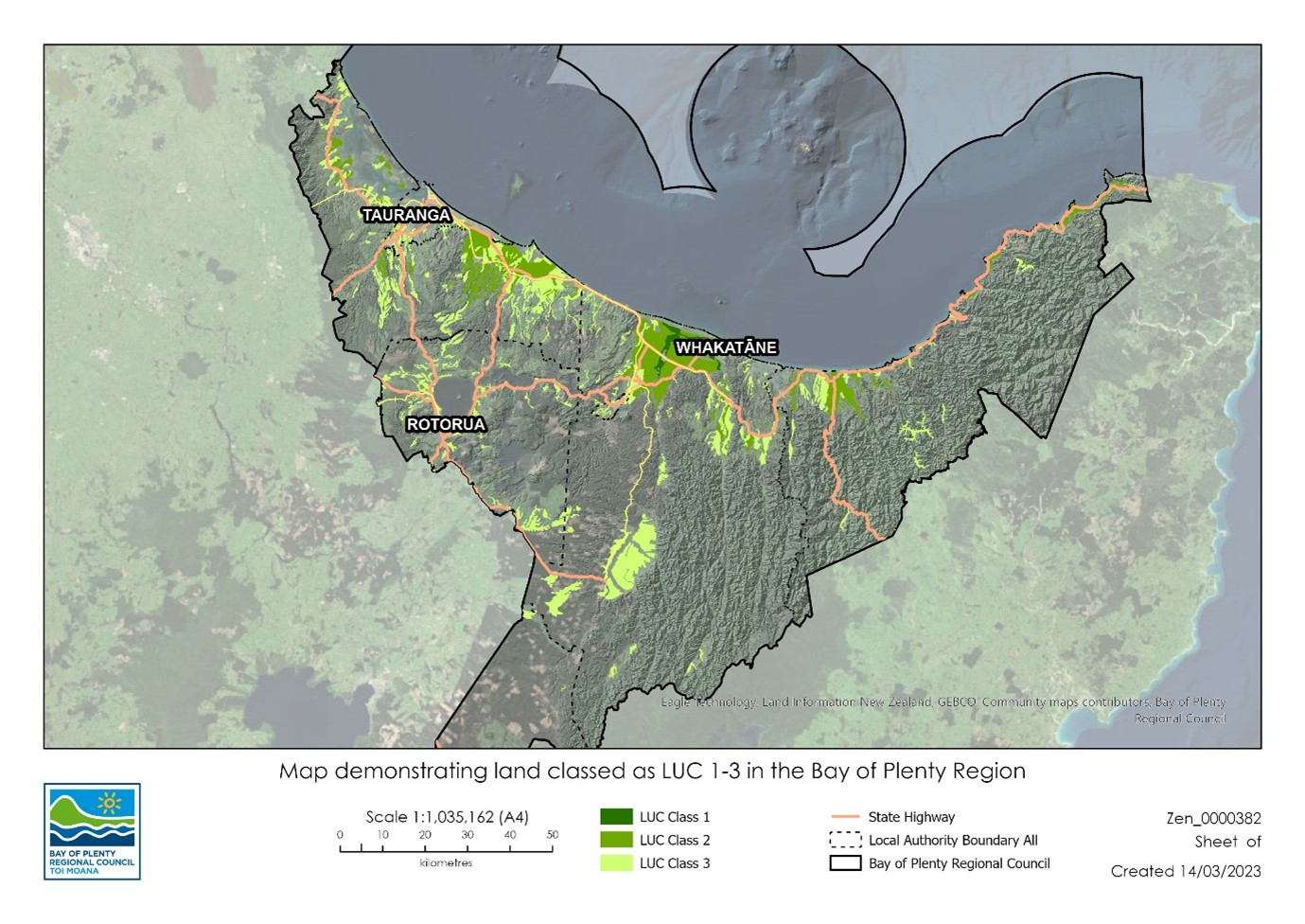
The high-level map below demonstrates highly productive land in the Bay of Plenty region. Note it doesn’t exclude areas currently zoned urban or rural lifestyle.
For the purpose of mapping highly productive land in the RPS the NPS-HPL defines highly productive land as:
- In a general rural zone or rural production zone; and
- Predominantly Land Use Capability classes 1, 2 or 3 land; and
- Forms a large and geographically cohesive area.
What are general rural or rural production zones?
District and city plans use different terms for general rural or rural production zone. If a zone provides issues, objectives, policies and rules that enable or provide for rural production activities as a predominant activity, then it will be considered as meeting the criteria in a) above. For example, the Ōpōtiki District Plan Coastal Zones includes Objective 9.2.5 which states: ‘Enable rural production activities in the Coastal Zone.’ It includes policies that guide actions toward providing for rural production activities recognising they are integral to and contribute to the rural use of the Coastal zone while seeking to avoid reverse sensitivity effects on them. It also provides for farming as a permitted activity in the zone.
Similarly, the Ōhiwa Harbour Zone recognises land in the zone is used for farming and horticulture which have operational requirements which need to be provided for [1]. Policy 11.2.1.5 provides for the continued operation of farming and horticulture and recognise their contribution to rural character and farming is provided for as a permitted activity [2].
[1] Resource management issue 11.1.1.10, pg 194 of the Operative Ōpōtiki District Plan 2021.
[2] Rule 11.3.2.1.1, pg 197 of the Operative Ōpōtiki District Plan 2021.
Highly productive land that won’t be mapped in the RPS
Highly productive land in urban zones or areas identified for future urban development will not be mapped in the RPS. Areas identified for future urban development means land identified in a published Future Development Strategy as suitable for commencing urban development over the next 10 years or identified:
- In a strategic planning document as an area suitable for commencing urban development over the next 10 years; and
- At a level of detail that makes the boundaries of the area identifiable in practice.
A strategic planning document means any non-statutory growth plan or strategy adopted by local authority resolution by the 17 October 2022.
Highly productive land in areas subject to urban zones will not be mapped in the RPS. The NPS-HPL defines what urban zones encompass which means any of the following zones:
(a) low density residential, general residential, medium density residential, large lot residential, and high density residential
(b) settlement, neighbourhood centre, local centre, town centre, metropolitan centre, and city centre
(c) commercial, large format retail, and mixed use
(d) light industrial, heavy industrial, and general industrial
(e) any special purpose zone, other than a Māori Purpose zone
(f) any open space zone, other than a Natural Open Space zone
(g) sport and active recreation.
Highly Productive Land - online ‘Webviewer’ tool
To assist with mapping requirements Toi Moana has developed an online HPL Webviewer. The HPL Webviewer assists with identifying whether land of interest contains highly productive land and will need to be mapped in the RPS. The Webviewer includes spatial layers of highly productive land - Land Use Capability (LUC) classes 1 (shown green), 2 (shown blue) and 3 (shown pink).
Land zoned general rural or rural production and contains highly productive land (i.e. Land Use Capability classes 1, 2 or 3) will be mapped in the RPS.
Note: while care has been taken to ensure the relevant rural zones from district plans are accurately depicted on the HPL Webviewer we recommend checking land shown as zoned rural against the relevant district plan zone maps. Where a discrepancy exists the district plan maps will take precedence.
Specified Māori Land and the NPS-HPL
The NPS-HPL exempts Specified Māori Land from restrictions on subdivision, use or development. The NPS-HPL defines ‘specified Māori land’ as land that is any of the following:
(a) Māori customary land or Māori freehold land (as defined in Te Ture Whenua Māori Act 1993):
(b) land vested in the Māori Trustee that—
- is constituted as a Māori reserve by or under the Māori Reserved Land Act 1955; and
- remains subject to that Act:
(c) land set apart as a Māori reservation under Part 17 of Te Ture Whenua Māori Act 1993 or its predecessor, the Māori Affairs Act 1953:
(d) land that forms part of a natural feature that has been declared under an Act to be a legal entity or person (including Te Urewera land within the meaning of section 7 of the Te Urewera Act 2014):
(e) the maunga listed in section 10 of the Ngā Mana Whenua o Tāmaki Makaurau Collective Redress Act 2014:
(f) land held by or on behalf of an iwi or hapū if the land was transferred from the Crown, a Crown body, or a local authority with the intention of returning the land to the holders of the mana whenua over the land.
Although the NPS-HPL does not restrict the type of activities that can occur on specified Māori land, proposed development or activities should minimise the actual and cumulative loss of highly productive land and not adversely affect the productive use of highly productive land on neighbouring sites.
National Policy Statement for Highly Productive Land (2022)
More information on the NPS-HPL can be found on the Ministry for the Environment's website.
Draft RPS Highly Productive Land Maps for the region
Draft RPS Highly Productive Land maps have been developed and are available below. The maps are based on the areas of Land Use Capability classes 1, 2 and 3 mapped in the online HPL Webviewer.
Proposed Change 8 (NPS-HPL) will likely be notified for submission in mid-2025. If you want to discuss the proposed change and draft maps we can arrange a meeting at a time and venue (either in person or virtually) that suits you.
Draft RPS Highly Productive Land map for Kawerau
Draft RPS Highly Productive Land maps for Ōpōtiki
- Ōpōtiki Map Overview
- Ōpōtiki Map 01
- Ōpōtiki Map 02
- Ōpōtiki Map 03
- Ōpōtiki Map 04
- Ōpōtiki Map 05
- Ōpōtiki Map 06
- Ōpōtiki Map 07
- Ōpōtiki Map 08
- Ōpōtiki Map 09
- Ōpōtiki Map 10
- Ōpōtiki Map 11
- Ōpōtiki Map 12
- Ōpōtiki Map 13
- Ōpōtiki Map 14
- Ōpōtiki Map 15
- Ōpōtiki Map 16
- Ōpōtiki Map 17
- Ōpōtiki Map 18
- Ōpōtiki Map 19
- Ōpōtiki Map 20
- Ōpōtiki Map 21
- Ōpōtiki Map 22
- Ōpōtiki Map 23
- Ōpōtiki Map 24
- Ōpōtiki Map 25
- Ōpōtiki Map 26
- Ōpōtiki Map 27
- Ōpōtiki Map 28
- Ōpōtiki Map 29
- Ōpōtiki Map 30
- Ōpōtiki Map 31
- Ōpōtiki Map 32
- Ōpōtiki Map 33
- Ōpōtiki Map 34
- Ōpōtiki Map 35
- Ōpōtiki Map 36
- Ōpōtiki Map 37
- Ōpōtiki Map 38
- Ōpōtiki Map 39
- Ōpōtiki Map 40
- Ōpōtiki Map 41
- Ōpōtiki Map 42
- Ōpōtiki Map 43
- Ōpōtiki Map 44
- Ōpōtiki Map 45
- Ōpōtiki Map 46
- Ōpōtiki Map 47
Draft RPS Highly Productive Land maps for Rotorua Lakes
- Rotorua Lakes Council Map overview
- Rotorua Lakes Council Map 01
- Rotorua Lakes Council Map 02
- Rotorua Lakes Council Map 03
- Rotorua Lakes Council Map 04
- Rotorua Lakes Council Map 05
- Rotorua Lakes Council Map 06
- Rotorua Lakes Council Map 07
- Rotorua Lakes Council Map 08
- Rotorua Lakes Council Map 09
- Rotorua Lakes Council Map 10
- Rotorua Lakes Council Map 11
- Rotorua Lakes Council Map 12
- Rotorua Lakes Council Map 13
- Rotorua Lakes Council Map 14
- Rotorua Lakes Council Map 15
- Rotorua Lakes Council Map 16
- Rotorua Lakes Council Map 17
- Rotorua Lakes Council Map 18
- Rotorua Lakes Council Map 19
- Rotorua Lakes Council Map 20
- Rotorua Lakes Council Map 21
- Rotorua Lakes Council Map 22
- Rotorua Lakes Council Map 23
- Rotorua Lakes Council Map 24
- Rotorua Lakes Council Map 25
- Rotorua Lakes Council Map 26
- Rotorua Lakes Council Map 27
- Rotorua Lakes Council Map 28
- Rotorua Lakes Council Map 29
- Rotorua Lakes Council Map 30
- Rotorua Lakes Council Map 31
- Rotorua Lakes Council Map 32
- Rotorua Lakes Council Map 33
- Rotorua Lakes Council Map 34
- Rotorua Lakes Council Map 35
- Rotorua Lakes Council Map 36
Draft RPS Highly Productive Land maps for Tauranga City
Draft RPS Highly Productive Land maps for Western Bay of Plenty
- Western Bay Map - Overview
- Western Bay Map 01
- Western Bay Map 02
- Western Bay Map 03
- Western Bay Map 04
- Western Bay Map 05
- Western Bay Map 06
- Western Bay Map 07
- Western Bay Map 08
- Western Bay Map 09
- Western Bay Map 10
- Western Bay Map 11
- Western Bay Map 12
- Western Bay Map 13
- Western Bay Map 14
- Western Bay Map 15
- Western Bay Map 16
- Western Bay Map 17
- Western Bay Map 18
- Western Bay Map 19
- Western Bay Map 20
- Western Bay Map 21
- Western Bay Map 22
- Western Bay Map 23
- Western Bay Map 24
- Western Bay Map 25
- Western Bay Map 26
- Western Bay Map 27
- Western Bay Map 28
- Western Bay Map 29
- Western Bay Map 30
- Western Bay Map 31
- Western Bay Map 32
- Western Bay Map 33
- Western Bay Map 34
Draft RPS Highly Productive Land maps for Whakatāne
- Whakatāne Map Overview
- Whakatāne Map 01
- Whakatāne Map 02
- Whakatāne Map 03
- Whakatāne Map 04
- Whakatāne Map 05
- Whakatāne Map 06
- Whakatāne Map 07
- Whakatāne Map 08
- Whakatāne Map 09
- Whakatāne Map 10
- Whakatāne Map 11
- Whakatāne Map 12
- Whakatāne Map 13
- Whakatāne Map 14
- Whakatāne Map 15
- Whakatāne Map 16
- Whakatāne Map 17
- Whakatāne Map 18
- Whakatāne Map 19
- Whakatāne Map 20
- Whakatāne Map 21
- Whakatāne Map 22
- Whakatāne Map 23
- Whakatāne Map 24
- Whakatāne Map 25
- Whakatāne Map 26
- Whakatāne Map 27
- Whakatāne Map 28
- Whakatāne Map 29
- Whakatāne Map 30
- Whakatāne Map 31
- Whakatāne Map 32
- Whakatāne Map 33
- Whakatāne Map 34
- Whakatāne Map 35
- Whakatāne Map 36
- Whakatāne Map 37
- Whakatāne Map 38
- Whakatāne Map 39
- Whakatāne Map 40
- Whakatāne Map 41
- Whakatāne Map 42
- Whakatāne Map 43
- Whakatāne Map 44
- Whakatāne Map 45
- Whakatāne Map 46
- Whakatāne Map 47
- Whakatāne Map 48
- Whakatāne Map 49
- Whakatāne Map 50
- Whakatāne Map 51
- Whakatāne Map 52
- Whakatāne Map 53
- Whakatāne Map 54
- Whakatāne Map 55
- Whakatāne Map 56
- Whakatāne Map 57
- Whakatāne Map 58
- Whakatāne Map 59
- Whakatāne Map 60
Key contact
For more information on Proposed Change 8 (NPS-HPL), contact Nassah Rolleston-Steed, Principal Advisor, Policy and Planning. Email: nassah.steed@boprc.govt.nz or phone 0800 884 880.