
Rangitāiki-Tarawera Rivers Scheme
The Rangitāiki-Tarawera Rivers Scheme covers the Rangitāiki River with a 3005km2 catchment and the Tarawera River with a 984km2 catchment.
This is our biggest Rivers Scheme, and extends all the way down to Rangitāiki in the Taupō District, covering Murupara, Galatea, Waiohau, Te Teko, Kawerau, Edgecumbe and Thornton. It covers rivers streams and tributaries in the area, as well as the region’s longest river – the Rangitāiki – which is 155km long.
It also includes some of the Rotorua Lakes, such as Tarawera, Ōkāreka, Ōkataina, and Tikitapu.
It is one of five major Rivers Schemes that were established in the 1970s by Regional Council (then known as the Catchment Commission) to effectively manage and maintain the flood defences along the awa, to help protect the lives and livelihoods of the community.
Andrew Pawson, Rangitāiki - Tarawera River Scheme Area Engineer, tells us more:

This scheme includes:
Bay of Plenty Regional Council owns and manages an array of flood protection and drainage defences across the rohe (such as stopbanks, floodgates, floodwalls etc).
As well as developing new or improved flood defences, our team undertake regular work to test, check, repair and maintain these defences.
We do this to make sure they are in good condition, so that when a flood event occurs, the flood defences will help manage the impacts to the community.


Latest rainfall and river levels
You can also access all rainfall and river level data through our Environmental Data Portal.
All ratepayers across the region contribute to river and drain management. However, if you live within a scheme, you pay an additional targeted rate for the services that you directly benefit from (such as flood protection and drainage).
Find out more information about the River Scheme, Pump & Drainage Scheme targeted rates.
What’s happening in the scheme?
Three concrete floodwalls on the Rangitāiki River are being replaced to ensure they continue to help protect the community from flooding in the coming decades.
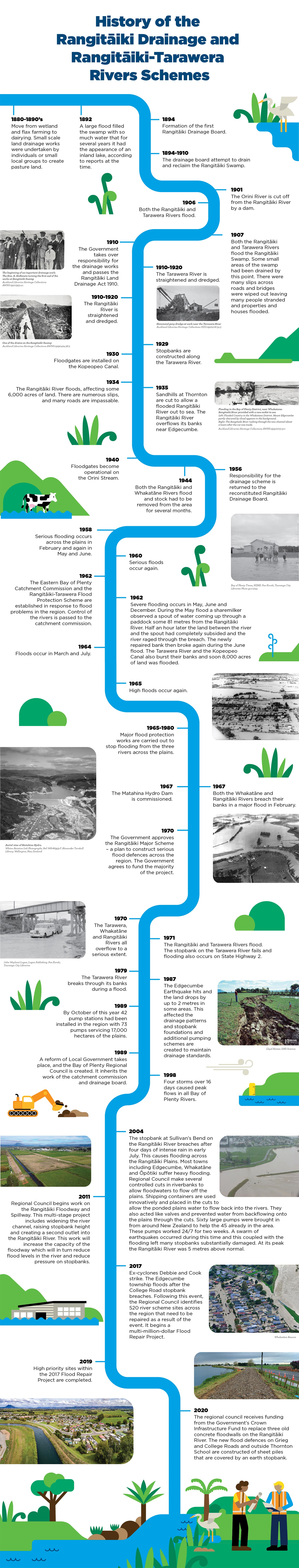
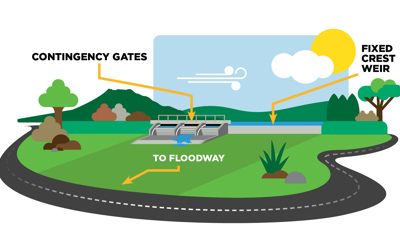
The Rangitāiki Floodway is a multi-stage project designed to take pressure off the Rangitāiki River in a flood event.
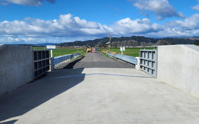
We’re upgrading more than 2km of stopbanks along the lower Rangitāiki River (next to Thornton Beach Road).
Scheme news and updates
Please be advised to expect disruptions along Thornton Beach Road, north of Moore Road, from next week.
Contractors will be installing a culvert through the road as part of the upgrade works required for the Lower Rangitāiki River stopbank with traffic temporarily shifted through the worksite.
Night works are expected to occur on Tuesday, 12 March between approximately 5pm to 2am. Traffic management will remain in place until works are complete, but if you are travelling through the area, please take care.
If you have any questions or concerns, please contact 0800 884 880.
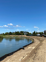
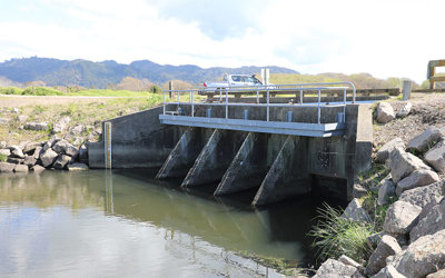
Construction has begun on the Rangitāiki River Spillway located next to Hydro Road, following a karakia led by Ngāti Awa late last year.
The Spillway is the final stage of the Rangitāiki Floodway project, which has been underway since 2011, and will improve the level of flood protection offered to the community.
Works on the Rangitāiki – Tarawera Rivers Scheme for the week 8 January to 12 January 2024.
Works on the Rangitāiki – Tarawera Rivers Scheme for the week 29 August to 1 September 2023.
Works on the Rangitāiki – Tarawera Rivers Scheme for the week 24 July to 28 July 2023.
When taking on a project, Managing Director of Romanes Construction, Paul Romanes, always looks to employ locals to be part of his crew.
Bay of Plenty Regional Council Councillors have approved increase in budget for the construction of the Rangitāiki Spillway, following overwhelming support from the community.
In an event, the Spillway enables water from the Rangitāiki River to pass over a fixed crest weir (lowered, concrete-covered stopbank) and into the Floodway. This will help divert water away from the Rangitāiki River and reduce the risk of significant flood damage to both rural and urban areas.
With increased rainfall and weather events impacting the region, Bay of Plenty Regional Council is reminding landowners living near the region’s flood defences to refresh themselves of the rules.
Bay of Plenty Regional Council is encouraging residents living or working in and around Edgecumbe to have their say on the Rangitāiki Spillway project.
Bay of Plenty Regional Council will begin construction for the final stage of the Rangitāiki Floodway in March 2023.
Works are underway to upgrade the floodwall along College Road in Edgecumbe township.
We will be undertaking geotechnical investigations on the Tarawera River between the river mouth and Braemar Springs next week.
These investigations are part of our efforts to understand more about the condition of our flood defences below the surface.
We’re two thirds of the way through the floodwall replacements with the Greig Road and East Bank Road walls now complete.
Watch this video to see all the progress we’ve made this year:
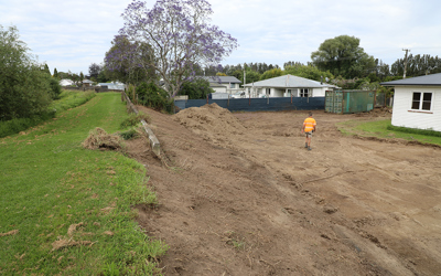
We’re removing 13 trees on or near the stopbank at Edgecumbe Rugby Park over the next couple of weeks.
Unfortunately these trees have been flagged in one of our condition assessments as being in various stages of decay which can cause issues in the stopbank during heavy rain events.
We’ll be removing the trees, stumps and roots and then compacting and stabilising the stopbank and ask you to please keep your distance while we undertake this work.
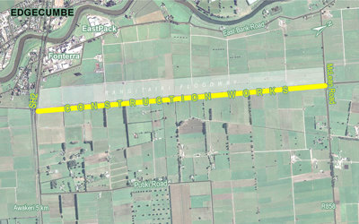
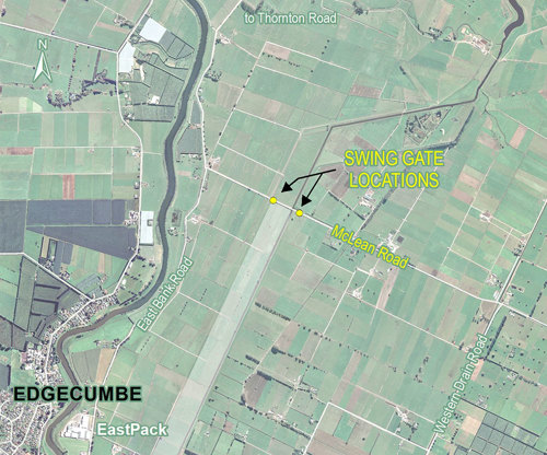
We are recommencing work on the Rangitāiki Floodway project on the outskirts of Edgecumbe in the section located between SH2 and Mclean’s Road.
Please take extra care on the roads around the site, we’ll be taking extra care too.
We're doing this work to improve how water travels down the floodway which will reduce the pressure on the Rangitāiki River stopbanks during large flood events.
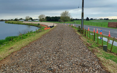
We are making good progress on replacing three concrete floodwalls on the Rangitāiki River to ensure they continue to help protect our communities from flooding in the coming decades.
Given all the flood prevention works that occurred last year, there is only one essential engineering project operation that is continuing through Alert Level Four - that is the Waiotahi contractors work at East Bank road, Thornton. The rationale is that the stopbank there is currently half constructed and cannot be left in a vulnerable state in case the river rises in a rain event.
Take a look at the progress we’ve made on upgrading one of our floodwalls on the lower Rangitāiki River:
Bay of Plenty Regional Council will begin works at the Old Rangitāiki Channel outlet, near the Tarawera River mouth, next week (Monday, 3 April).
Subscribe and stay up to date
Sign up and receive regular emails about what's happening in your River Scheme.
Your River Scheme Advisory Group
Flood protection is an ongoing conversation with the community, to help balance the social, cultural, economic and environmental impacts that flood protection presents.
To help achieve this, we established River Advisory Groups, which are made up of local people from along the river with different interest and involvements in the future of the awa. These locals are here to represent your needs and wants for the awa, which helps advise our teams when it comes to flood projects, maintenance and management.
Find out more the Rangitāiki-Tarawera Rivers Scheme Advisory Group.
Co-governance forum
The Rangitāiki River Forum was formed in May 2012 by law to protect and enhance the mauri (life-giving capacity) of the Rangitāiki River and its tributaries.
Find out more about the Rangitāiki River Forum.