Skip to main content Skip to footer
Menu
Te Mania Catchment Te Mania Catchment

Te Mania Catchment

The 1,300 hectare Te Mania catchment is located approximately 3km south of the township of Katikati in the Bay of Plenty.

The catchment of the Te Mania Stream and its unnamed tributaries extend north-eastward from headwaters in the Kaimai-Mamaku Forest Park at over 400m above sea level. It covers a distance of around 7km down to a shallow bay in the mid-reach of the Tauranga Harbour, known as Rereatukahia Estuary. The Te Mania Stream catchment includes 28km of streams (11 tributaries) and 1.7km of harbour margin.

Land use in the catchment is mainly:

  • Dairy support (20%)
  • Dry stock (22%)
  • Horticulture (approximately 12%)
  • Lifestyle blocks or mixed land use (26%)

Land use in the upper catchment outside of the Kaimai-Mamaku Park is mostly moderate to intensive dry-stock grazing scattered with patches of remnant native vegetation on steeper land with erosion limitation (Land Use Capability (LUC) 6e and 7e land).

Horticultural developments dominated by kiwifruit and avocado are common alongside dry-stock grazing on the rolling terraces of the mid-catchment (LUC Class 3e and 4e land, rolling but still limited by erosion), with horticulture preferring the flatter ground.

A small but growing residential development of around 40 dwellings is also present in the lower catchment closest to the estuary, as well as a commercial pack-house facility. . 

The main soil types in the catchment are "Katikati Sandy Loam" and "Katikati hill soils", which belong to the Katikati soil series. They are derived from air fall ash.

Soils on the stream flats are recent and consist of fluvial sands, silts, gravels and boulders.  Being volcanic in nature, the Katikati hill soils are resilient, well drained and versatile. Due to poor cohesive properties this also makes them vulnerable to erosion in conditions like inadequate vegetative cover or root system binding (Rijske, 2010).

A steep upper catchment combined with a lack of soil cohesiveness means the catchment has high inherent risk factors for contaminant loss.

Based on previous long term monitoring in the Te Mania Stream (Hamill et al., 2020) and in the Rereatukahia Estuary (Park, 2015, 2016; Crawshaw, in prep.; Lawton & Conroy, 2019), the key water quality issues identified in the Te Mania catchment are elevated bacteria (E.coli), Total Suspended Solids (TSS) and Ammoniacal-Nitrogen.

Water monitoring summary

  • Water quality monitoring has occurred regularly in Te Mania Stream since 1990.
  • Environmental issues in the Te Mania catchment are elevated coli bacteria, total suspended solids (sediment) and Ammoniacal Nitrogen.
  • Te Mania Stream flows into the Rereatukahia Estuary which is part of Tauranga Harbour.
  • Rereatukahia Estuary has high mud content from the sediment in Te Mania Stream.

There have been improvements in land management practices throughout the catchment, including improved stock management, riparian retirement and fencing, which are likely to have contributed to improving trends for Ammoniacal-N and turbidity at the Te Mania SH2 site, however these contaminants are still significant water quality issues in this catchment. The high mud content in the Rereatukahia Estuary between 2014 and 2019 (Crawshaw, in prep.) indicates that sedimentation is continuing to have a negative impact on the receiving environment.

E.Coli and Faecal Source Tracking

Fourteen E. coli samples from a 2019/2020 Te Mania catchment investigation were tested for Faecal Source Tracking (FST). Nine samples were taken from a rainfall event to track the source of faecal bacteria from overland flow conditions, and five samples were taken in low flow conditions. The results showed that in both overland and low flow conditions, the dominant sources of E. coli bacteria in the Te Mania catchment were ruminant and avian animals. There was no human or dog faecal bacteria detected in the samples tested.

Ecological monitoring summary

The ecological state of the Te Mania Stream at Chard Road between 2014 and 2017 was considered ‘very good’ based on a ranking system developed by Carter et al. (2018).  This ranking system classifies ecological health on a scale of Poor to Very Good based on the Macroinvertebrate Community Index (MCI), the number of Ephemeroptera (mayflies), Plecoptera (stoneflies) and Trichoptera (caddisflies) (EPT) and the Bay of Plenty Index of Biotic Integrity (BOP_IBI). No clear trends in ecological condition have been determined for this site by Carter et al. (2018), indicating that the invertebrate community at this site is in a relatively stable state.

Historical freshwater fish monitoring at three sites in the Te Mania catchment in 1973 and 1999 identified longfin eel, torrentfish, banded kōkopu, inanga, common and redfin bullies, smelt and unidentified eels (A. Suren, personal communication, June 3 2020). The most recent freshwater fish monitoring in 2015 showed an increase in abundance of species and species richness (including the addition of shortfin eel to the species found in the catchment), increasing the Fish IBI from “moderate” in the older research to “good”.

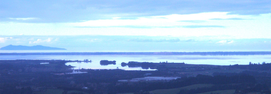
Receiving environment monitoring - Rereatukahia Estuary

Rereatukahia Estuary is the receiving environment of the Te Mania catchment. There are six NERMN estuarine sediment monitoring sites in Rereatukahia Estuary. Four have been monitored annually since 2014, and two monitored annually since 2019. Rereatukahia Estuary has an active estuary care group (Uretara Estuary Managers) which has developed an estuarine monitoring programme with support from BOPRC. This is linked with the NERMN (Natural Environment Regional Monitoring Network) monitoring conducted by BOPRC, with the addition of epifauna, macrofauna and bird counts conducted at each site.

Volunteer-led estuary monitoring by the Uretara Estuary Managers care group over recent years indicates poor species diversity and abundance of benthic fauna in Rereatukahia Estuary (Donald, 2020). Additionally, anecdotal observations of marine fish and shellfish are limited to three shellfish species, mud crabs and common marine fish species such as flounder, kahawai, grey mullet, yellowtail kingfish, snapper, trevally, sharks, stingrays, orca and longfin and shortfin eels (Donald, 2020). Gathering kaimoana is not common in the Rereatukahia Estuary due to low abundance of shellfish (L. Donald, personal communication, July 9 2020).

Seagrass used to cover 31 km2 within the estuary in 1959, however this has decreased to less than 0.2 km2 in 2011 (Park, 2016). Mangrove coverage has increased from 13 km2 in 2003 to 24 km2 in 2011 (Park, 2015). Rereatukahia Estuary has low coverage of nuisance macroalgae species, with Ulva spp. and Gracilaria chilensis having coverage ranging from 0% – 0.7% between 2015 and 2019. All sediment sites at Rereatukahia Estuary are either in the fair or poor banding for mud content, indicating poor sediment quality (Crawshaw, in prep.). Heavy metals are generally graded “very good”, with the exception of elevated mercury concentrations at one site. Sedimentation rates range from very good (<1 mm/year) to fair (>2 to <5 mm/year) (Lawton & Conroy, 2019).

Project Parore a very active community group is working to improve the situation, by promoting catchment wide Good Management Practice (GMP) on farms in the Te Mania and surrounding catchments.  The group also undertake an annual bio-blitz looking at water quality, Macroinvertebrate Community Index (MCI), fish and also quarterly bird monitoring. 

BOPRC efforts are geared to support this initiative to encourage ground up change and peer-to-peer engagement to promote good management practice. Since the Te Mania became a focus catchment in late 2019 we’ve increased our monitoring programme so that we better understand the catchments issues and though this programme is ongoing much of what we’ve learnt to date is presented in the preceding sections.  This work has led to the following objectives and planned activities:

  • Develop a Farm Environment Plan (FEP) for every property in the catchment within 5 years. Underpinned by Good Management Practice (GMP) and Critical Source Area (CSA) management these plans help landowners identify and mitigate their environmental impacts. 
  • Reduce overall concentrations of coli in the river to acceptable levels, with fewer incidences of ‘alert’ and ‘action’ bacteria concentration at monitoring locations (so it is swimable).
  • Improve suspended sediment level trends and associated nutrient loading through best-practice land management interventions.
  • Enhance biodiversity habitat within the catchment, including forest remnants, wetlands, and riparian areas.

Landowners can take action now. Regional Council offers practical advice and increased funding grants to help landowners within focus catchments to complete works that can contribute to improved water quality.

Funded works can include fencing, planting, nutrient budgeting, farm planning, detention bunds, treatment wetlands and many other activities. We can also help landowners to access funding from the Te Uru Rākau One Billion Trees Programme.

These incentives are for a limited time only.

  • Carter, R., Suren, A., Dare, J., Scholes, P. and Dodd, J. (2018). Freshwater in the Bay of Plenty – Comparison against the recommended water quality guidelines.  Bay of Plenty Regional Council Environmental Publication 2018/10.
  • Crawshaw, J. (in prep.). Tauranga Moana sub-estuary health overview 2019. Bay of Plenty Regional Council Environmental Publication 2020.
  • Donald, L. (2020). Marine life of Te Rereatukahia/Te Mania Estuary. Report in Uretara Estuary Managers Incorporated Activity Highlights 2018-2019. Uretara Estuary Managers Care Group.
  • Hamill, K. Dare, J. and Gladwin, J. (2020). River Water Quality State and Trends in the Bay of Plenty to 2018: Part A. Publication prepared for the Bay of Plenty Regional Council. River Lake Ltd, Whakatāne, New Zealand.
  • Lawton, R. & Conroy, E. (2019). Tauranga Moana State of the Environment Report 2019. Bay of Plenty Regional Council Environmental Publication 2019/04.
  • Rjiske, W.C. & Guinto, D.F. (2010). Soils of the Bay of Plenty, Volume 1: Western Bay of Plenty. Bay of Plenty Regional Council Publication 2010/11-1.
  • Park, S. (2015). 2011 Mangrove abundance in the Bay of Plenty. Bay of Plenty Regional Council Environmental Publication 2015/08.
  • Park, S. (2016). Extent of seagrass in the Bay of Plenty in 2011. Bay of Plenty Regional Council Environmental Publication 2016/03.

Find out more

Please contact us if you have question or would like to find out how you can get involved:

Braden Rowson, Bay of Plenty Regional Council Land Management Officer
Braden.Rowson@boprc.govt.nz
Ph: 0800 884 880