The Regional Coastal Environment Plan promotes sustainable management of the natural and physical resources of the Bay of Plenty's coastal environment.
The second generation Regional Coastal Environment Plan became operative on 3 December 2019.
Updates to the plan
In March 2021, the Minister of Conservation approved the remaining provisions of the Regional Coastal Environment Plan, resolving the two outstanding appeals relating to the Motiti Protection Area and Matakana Island. These new policies and rules have now been incorporated into the plan as follows:
Matakana Island
Provisions relating to Outstanding Natural Features and Landscapes (ONFL) 5 – Te Ure Koti Koti (Matakana barrier arm) are operative on Tuesday 18 May 2021.
Marine spatial provisions for Motiti
These provisions establish and protect three reef systems around Motiti Island making up the Motiti Protection Area and became operative on Wednesday 11 August 2021. Read more about these new rules and what it might mean for you on the Motiti Protection Area webpage.
What is the Regional Coastal Environment Plan?
Watch this video to find out:
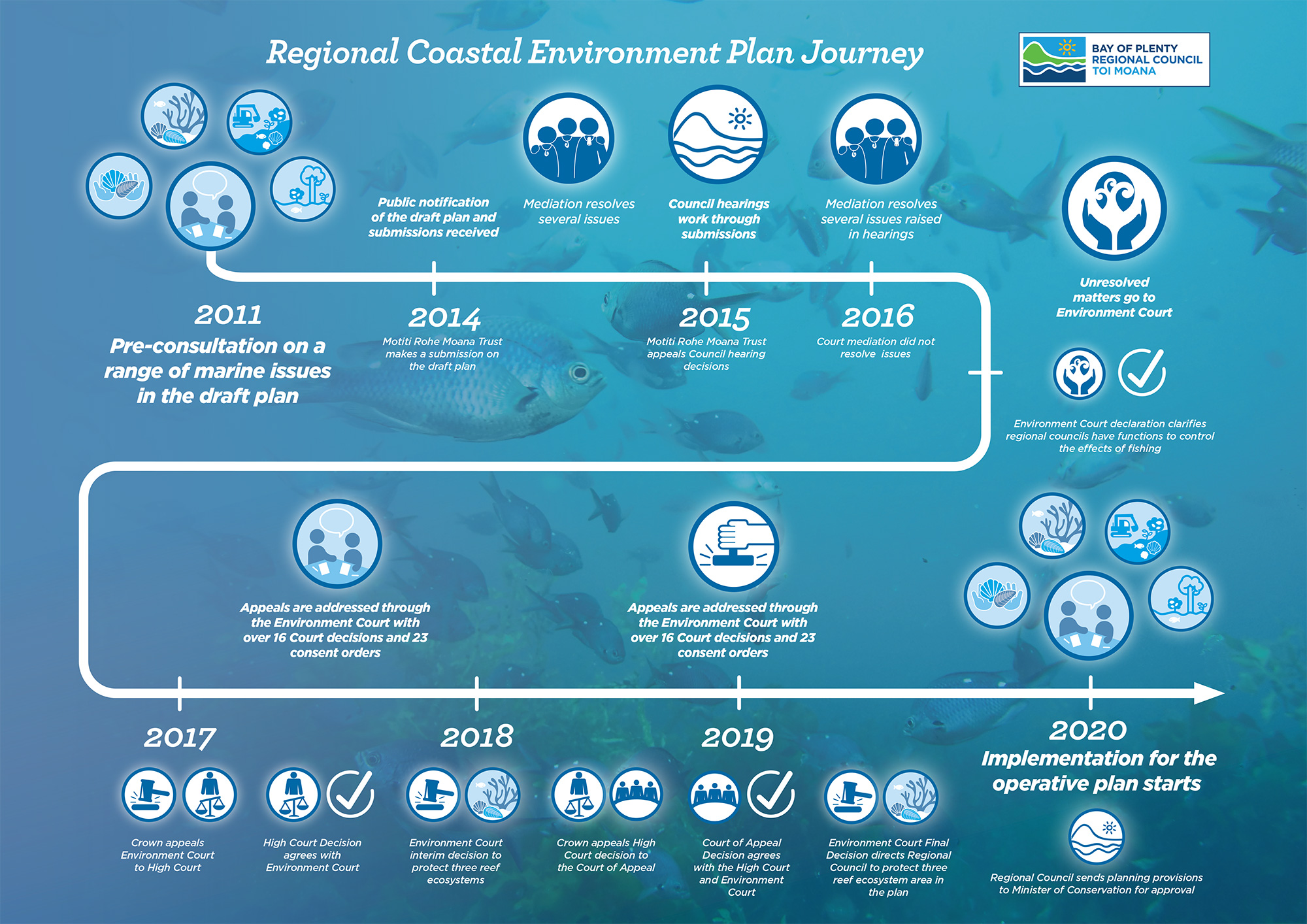
The Regional Coastal Environment Plan Journey
This plan has been in the making since 2011 and the journey has included multiple courts, hearings and appeals, plus iwi/hapū and stakeholder participation.
Operative Bay of Plenty Regional Coastal Environment Plan
The Plan covers the entire coastal environment including the coastal marine area (the area between mean high water spring tides and the '12 mile limit' of the territorial seas) and the land backdrop. It includes:
Rules to regulate some activities in the coastal marine area. This includes building of structures, disturbance of the foreshore or seabed, reclaiming the sea, discharging contaminants and other activities. These activities generally require a coastal permit from Council before they can be undertaken.
Policies about important environmental issues on land adjacent to the sea. This includes issues relating to the natural character and landscape of the coast, public access and coastal hazards. These policies do not regulate people's activities directly but provide guidance in the preparation of district plans and consideration of resource consents.
Fifteen schedules including site specific information on coastal values (including landscape, vegetation, bird habitat, conservation areas and culturally significant areas), development plans for the Ports of Tauranga and Whakatāne, water quality standards and environmental monitoring.
The planning maps cover the entire coastal strip of the region, including harbours and offshore islands and land backdrop at a scale of 1:25 000. The maps identify many of the special values of the coast that need protecting.
Council, territorial authorities and the Minister of Conservation are required to agree on the location of river mouths in the region, which are then used to establish the boundary of the coastal marine area in rivers that enter the sea.
The Coastal Marine Area Boundary and River Mouths were redefined in 2008 by a new agreement signed by the relevant territorial authorities (Western Bay of Plenty District Council, Tauranga City Council, Whakatāne District Council and Ōpōtiki District council), Council and the Department of Conservation (acting on behalf of the Minister of Conservation). These boundaries can be found on the Regional Coastal Environment Plan maps, while descriptions of their locations can be found in Schedule 1 of the text.
The following signed agreement and maps are available for you to download:
The Ngā Whakaaetanga-ā-Ture ki Te Taiao ā Toi (Statutory Acknowledgements in the Bay of Plenty) is a compendium document to be read as an attachment to and in conjunction with the Operative Regional Coastal Environment Plan including any proposed regional plan or policy statement, and any variation or change notified by the Bay of Plenty Regional Council. Check out the Statutory Acknowledgements for more information.
Order a copy of the Operative Coastal Plan
Order a copy of the Operative Regional Coastal Environment Plan (RCEP) by phone on 0800 884 880 or email us at info@boprc.govt.nz. The plan is in two volumes (Volume 1 Text & Volume 2 Maps) at a cost of $30 each (GST Inclusive).
The Plan is also available to view at the Bay of Plenty Regional Council offices, all public libraries throughout the Bay of Plenty and service centres of Bay of Plenty's City and District Councils.
Key contact
Get in touch with Stacey Faire regarding the Regional Coastal Environmental Plan on 0800 884 880, ext 8317.