Skip to main content Skip to footer
Menu
Kopurererua catchment, Carmichael Reserve-5 Kopurererua catchment, Carmichael Reserve-5

Kopurererua Catchment

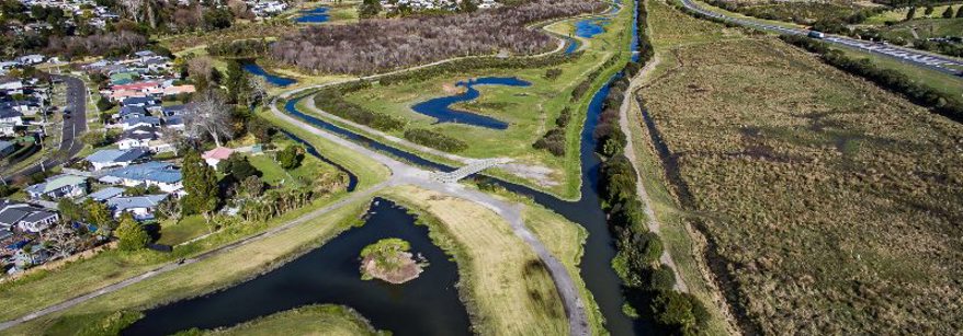
We’re working with Ngai Tamarawaho, Tauranga City Council, Western Bay of Plenty District Council, community volunteers, and landowners to protect the health of the Kopurererua Stream and the Waikareao Estuary that it flows into - maintaining its recreational, ecological and cultural values.

To achieve this long term goal it’s necessary to reduce the E.coli levels and volume of sediment entering the waterways of the Kopurererua Catchment.

About the catchment

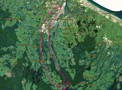
The Kopurererua Catchment is approximately 7,400ha in area and is located south-west of Tauranga City and flows north from the Mamaku Plateau down to Tauranga Harbour, entering the Tauranga harbour at the Waikareao Estuary. Kopurererua is 29 km long and has two tributary streams (Tautau and Nanaku) and numerous unnamed tributaries. Tautau is the largest tributary at approximately 18.5 km long and is one of the two spring fed awa supplying water for Tauranga City.

There are an abundance of springs lining the mid-upper valley walls and floor.

Within the catchment there are three distinct areas that influence water quality:

The Lower Catchment spans between the Waikareao Estuary and current extent of ongoing urban-industrial development in Tauriko and Pyes Pa. Land use is a mix of urban, industrial, and public open space (K-Valley wetland reserve).

The watercourses in these areas are heavily modified due to land use pressure. The Kopurererua main stream was straightened pre-1940, disconnecting the lower river reaches from its floodplain. Its associated wetlands were drained over the years in attempts to convert the Valley to pasture.

The Mid Catchment transitions to rural land use through upper Tauriko and Pyes Pa, with lifestyle blocks and farmland dominating the valley floors and orchards dominating the upper plateaus. Here, the Kopurererua stream still follows its natural, meandering course.

Land use practices over the last century have led to a loss of native forest cover and watercourse modification. Ongoing development is occurring in the Tauriko industrial estate along Kopurererua Stream and in Pyes Pa along Nanakau Stream. There is some lifestyle development in the valleys.

The Upper Catchment in Omanawa and Oropi includes orchards, lifestyle blocks and dry stock farmland with some dairy farming, and plantation forestry on the upper plateau. The steep gorges are largely covered in regenerating indigenous tawa-broadleaf forest.

Te Ao Māori

The now–drained plains of the lower catchment were once part of a large wetland taonga (treasure) that was prized by Ngai Tamarawaho.

Ngāi Tamarāwaho have occupied the area for centuries and are kaitiaki of the land and waters within. The Ngāi Tamarāwaho hapū management plan (PDF 8.73MB) outlines a co-operative approach to environmental and resource management within the rohē.

Current water quality issues

In the catchment there are three major contributors of sediment and phosphates. These are coming from storm water runoff from farm and forestry activities, stream bank erosion and from urbanisation in the lower catchment. The high volumes of sediment in the water mean that the catchment falls within the top 5% of worst sites sampled in the Bay of Plenty.

Livestock access to a stream or wetland, degrades water quality by increasing faecal matter (E.coli) and sediment in the waterway. Consistently medium – high levels of E.coli concentrations are of concern – particularly for those who use the kayak gates in Judea.

Water quality monitoring

A combined effort between Bay of Plenty Regional Council, Tauranga City Council and Western Bay of Plenty District Council saw a 12-month monitoring plan started in May 2019 to better understand the high sediment and E.coli water quality issues in the catchment.

For the latest test results go to: Kopurererua Web Portal

Key actions to improve water quality

We’ve increased our science and monitoring efforts in the catchment to investigate sediment and nutrients hot spots and tributaries. The more information we can gather on water quality in the area, the more targeted and effective our efforts can become.

Stream Re-alignment and wetland restoration

  • We are supporting Tauranga City Council and Ngāi Tamarawaho with the Kopurererua re-alignment project which aims to realign and restore the natural path of the Kopurererua Stream. The main objectives of this project are to:
    • To reduce sediment entering the Waikareao estuary and harbour by allowing it to settle in the newly created wetland
    • To improve community access to the area
    • To enhance ecological and cultural values in the area

We are contributing $1.3million towards the project over the next 3 years and work commenced on 1 February 2022.

Wetland restoration for fish passage

At the bottom of the catchment, further downstream from the realignment project, council is working alongside Ngāi Tamarawaho, with the help of funding from the Port of Tauranga/Ngā Matarae Trust, to restore waterflow to the Koromiko wetland. The purpose of this project is to improve fish passage, (primarily for inanga) into the wetland and provide habitat for inanga spawning.

The lower part of this stream has been heavily modified over time, absent of any native riparian vegetation and has a heavy presence of the invasive weed glyceria which negatively impacts on spawning opportunities for inanga. This project aims improve habitat in the riparian zone and reinstate part of the original meander of the Kopurererua stream into the Koromiko wetland.

Work should commence on this project later in 2022.

There is recognition of the cultural values of the now-drained plains and the need for inclusion of matauranga Maori (traditional knowledge) in finding solutions.


We are working with smaller lifestyle block holders and horticulturalists to:

  • Protect floodplain areas
  • Control willows which are causing riverbank issues
  • Protect and enhance existing wetlands
  • Exclude stock from waterways

We are working with 4 out of 5 of the larger farms in the headwaters of the Kopurererua catchment to:

  • Retire highly erodible hillslopes by fencing and planting
  • Protect existing stands of native bush blocks
  • Build detention bunds to trap sediment

Funding assistance and practical advice for landowners

Landowners can take action now. Regional Council offers practical advice and funding subsidies to help landowners and community groups complete works that can improve water quality as well as land and business productivity.

Funded works can include fencing, planting, nutrient budgeting, farm planning, detention bunds, plant or animal pest control, treatment wetlands and many other activities. 

Get involved

If you have questions, or would like to get involved, please contact our local Land Management Officer Katherine Glasgow by email at Katherine.glasgow@boprc.govt.nz